Daniel C. McCarthy, News Editor
Coral, the world's largest living organism, is in danger from rising ocean temperatures. An increase of only 2 °C in reef waters poses serious threats to coral life and to the industries surrounding them, such as tourism and fishing. As part of the US government's Coral Reef Initiative, the National Oceanographic and Atmospheric Administration (NOAA) is evaluating the use of hyperspectral imaging technology from 3DI LLC to assess the health of coral reefs.
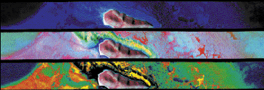 Hyperspectral imaging of coral reefs in Buck Island National Marine Reserve and elsewhere is aiding evaluation of coral health and mortality. Courtesy of the National Oceanographic and Atmospheric Administration.
Prior to the initiative, mapping of coral reefs relied largely on aerial photogrammetry, which is essentially aerial photography corrected through triangulation to minimize errors from lens aberration, aircraft pitch or yaw, and other factors. But by itself, aerial photography provides limited information about coral status. Hence, the initiative specifically calls for evaluation of new mapping methods such as remote sensing.
"[NOAA] just finished an assessment of a coral reef in the Florida Keys that took seven years to complete," said William Bernard, director of remote sensing at 3DI. "By the time you're done, it's time to start over. We could have done the same thing with greater detail in two years [with the current system]."
At the heart of 3DI's system is the Aisa hyperspectral sensor from Spectral Imaging Ltd. (Specim). A global positioning navigation system integrated into Specim's sensor enables it to provide pixel-location information to correct data.
The push-broom sensor is the size of a cigar box. From the air, the device can capture spectra reflected between 430 and 900 nm. In flight, it digitally collects 26 to 33 bands of data with a cross-track pixel count proportional to flight height: 1000-m altitude provides 1-m cross-track pixel, 2000-m altitude provides 2-m cross-track pixel, etc. Besides speeding the collection of data, the sensor can also provide knowledge of bottom and coral types, coral health or mortality, as well as progressive changes. Bernard also attributes 3DI's selection of the Specim sensor to its down-welling irradiance feature. Downward radiance signal collected at the top of the aircraft is fiber optically linked with the spectrograph to provide a simultaneous measurement of down-welling irradiance with the same wavelength range as the actual measurement. This helps correct incidental sunlight reflecting off the scene being imaged.
"We can compare this data from scene to scene, day to day, field to field to learn the strength of sunlight falling, and average out the variables," Bernard said.