Dr. Frank J. Vallese, !%Sofradir EC Inc.%!
Recent advancements in cooled IR detector
technology have led to the rapid development of many IR remote sensing instruments
for a wide variety of environmental applications, including hyperspectral remote
sensing, space imaging and surveillance. Because of the extraordinarily high sensitivity
of cryogenically cooled detectors, IR systems have been developed for imaging in
a variety of spectral bands with wave-lengths up to 25 μm.
Many hyperspectral remote sensing systems are available in the
very near IR and short-wavelength IR (SWIR) band. Reconnaissance systems –
and even some meteorological and environmental observations systems – operate
in the mid-wavelength (MWIR) and long-wavelength (LWIR) infrared bands. System performance
depends on detector format – including both linear and two-dimensional arrays
– as well as on array and pixel sizes. For use in space missions, rugged IR
detectors have been constructed that deliver high performance and reliability after
extensive qualification.
Remote sensing
Remote sensing instruments that use IR detector arrays have continued
to increase as new applications are identified and new detector technology is developed.
The IR sensors used to sample radiation emitted, reflected or transmitted by land
surfaces, oceans or the atmosphere can extract information about features, objects
and classes of those objects. Remote sensing instruments typically are found aboard
Earth-viewing research aircraft or satellites (see Figure 1) and provide global
measurements of data for civil, research and military purposes. The instruments
also have conducted remote sensing studies in extraterrestrial environments aboard
spacecraft, rovers and space probes.
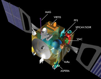
Figure 1. Venus Express, shown in this cutaway diagram, has been
in orbit around Venus since 2006. Spectroscopy for Investigation of Characteristics
of the Atmosphere of Venus (SPICAV), an onboard remote sensing instrument, uses
a Sofradir detector to study IR absorption of solar radiation in the mid-wave bandto
glean characteristics about the Venusian atmosphere. MAG = magnetometer; VIRTIS
= visible and infrared thermal imaging spectrometer; PFS = planetary Fourier spectrometer;
SOIR = solar occultation at infrared; VMC = Venus monitoring camera; VeRa = Venus
radio science; ASPERA = Analyser of Space Plasmas and Energetic Atoms. Courtesy
of the European Space Agency.
Multispectral IR remote sensing systems create images in several
spectral bands. Since 1972, the Landsat program, jointly managed by NASA and the
US Geological Survey, has contributed significantly to the maturing of remote sensing
instruments, collecting information from space during its Earth-observing satellite
missions. Landsat has implemented several generations of multispectral sensors that
have subdivided the electromagnetic spectrum into distinct wavelength bands. The
resulting images could be used to broadly classify land areas being observed, enabling
the creation of maps to monitor land usage and highlighting areas of healthy vegetation,
uncultivated fields and urban areas.
 As multispectral sensing systems evolved, it became possible to
better identify land cover to prospect for minerals, to examine the health of indigenous
plants, to detect chemicals with distinctive emission spectra (such as chemical
weapons), to detect camouflaged vehicles, to monitor oil spills and to collect data
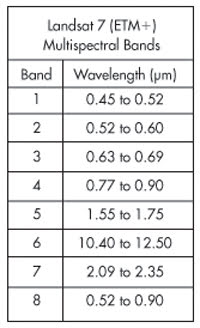
on chemical concentrations in the atmosphere. As an example of a multispectral imager,
the Enhanced Thematic Mapper Plus, or ETM+, on Landsat 7 (launched in 1999) has
eight bands – as shown in the accompanying chart – seven for detecting
reflected energy and one for detecting emitted energy. Spectral data are used to
discriminate between certain earth-surface materials based on expected spectral
performance.
As multispectral sensing systems evolved, it became possible to
better identify land cover to prospect for minerals, to examine the health of indigenous
plants, to detect chemicals with distinctive emission spectra (such as chemical
weapons), to detect camouflaged vehicles, to monitor oil spills and to collect data
on chemical concentrations in the atmosphere. As an example of a multispectral imager,
the Enhanced Thematic Mapper Plus, or ETM+, on Landsat 7 (launched in 1999) has
eight bands – as shown in the accompanying chart – seven for detecting
reflected energy and one for detecting emitted energy. Spectral data are used to
discriminate between certain earth-surface materials based on expected spectral
performance.
More recently, hyperspectral sensors have revolutionized IR remote
sensing systems, greatly improving spectral performance. Different from multispectral
sensors that capture data in distinct spectral bands, hyperspectral sensors can
capture a near-continuous spectral range by collecting data in many very narrow
spectral bands (typically 10 to 20 nm) over a broad, continuous range, such as from
the visible to 2.5 μm. As a result, the amount of data captured is significantly
larger than that from multispectral systems. As shown in Figure 2, a hyperspectral
data cube is acquired, which can be considered as a group of images of an observed
area, with each image corresponding to the spectral reflectance of the area in a
specific narrow spectral band.
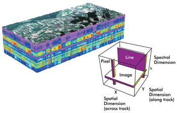
Figure 2. Image data from hyperspectral imagers can be thought of as creating a cube of
data composed of two spatial dimensions and one spectral dimension. The spectral
dimension consists of many spectral data layers, each consisting of the reflectance
in a 10-nm-wide spectral band, for example. Analysis of a single pixel in the cube
reveals a spectral reflectance histogram for that surface position. Courtesy of
Sofradir.
The major advantage of hyperspectral sensors over broadband multispectral
sensors is their ability to better discriminate materials based on their thermal
signatures. This is because individual materials exhibit variations in their spectral
composition, seen as slight shifts in their spectral reflectance characteristics.
For example, although multispectral sensors can identify vegetation versus uncultivated
fields based on their performance in certain distinct spectral bands, hyperspectral
imagers can discern alfalfa, barley, canola and spinach crops based on their spectral
reflectance properties. Today, hyperspectral data cubes are generated from several
NASA instruments, including the Hyperion and Airborne Visible/Infrared Imaging spectrometers
(AVIRIS).
IR detector arrays
Although early remote sensing instruments were based on IR detectors
comprising either single detectors or linear arrays used in conjunction with electro-
mechanical scanners, new detector technologies exhibit significant performance improvements,
delivering staring arrays that do not require the same scanning mechanism. For demanding
applications, cooled detector arrays have been developed with extraordinary sensitivity
to IR radiation. The cooling of these detectors reduced thermal noise (IR radiation
from sources other than the objects being observed) to very low levels and resulted
in the rapid growth of applications such as hyperspectral remote sensing, space
imaging and surveillance.
A variety of IR detector materials have been used in remote sensing
instruments, including silicon, mercury cadmium telluride (MCT), indium gallium
arsenide, indium antimonide and quantum well IR photodiodes. Because of their maturity,
high performance and broad spectral response properties (see Figure 3), MCT IR detectors
have become the most widely used in remote sensing applications. They are available
with high sensitivity in the full spectrum from visible to very long wave IR (VLWIR).
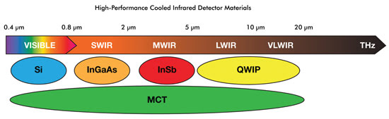
Figure 3. Mercury cadmium telluride (MCT) has unique properties that
make it an ideal detector candidate to meet the need for IR detection in the spectral
bands from visible, short-wave, mid-wave, long-wave and very long wave IR. QWIP
= quantum-well infrared photodetector. Courtesy of Sofradir.
The spectral range selected for IR remote sensing systems will
depend on the intended application. Systems designed for commercial, scientific
and science applications typically operate in the SWIR spectral range from 0.8 to
2.5 μm. Military applications for Earth observation, on the other hand, traditionally
operate in MWIR (3 to 5 μm) and LWIR (8 to 12 μm) spectral ranges. Other
applications, such as meteorology or greenhouse-effect monitoring, are based on
the VLWIR spectral range (12 to 25 μm).
With improvements in IR detector technology, large one- and two-dimensional
IR detector arrays now are available. To operate with low noise as desired, the
detectors must be cooled to a very low temperature, typically between 50 and 200
K. To accomplish this, the detector is mounted in a sealed Dewar and either integrated
with a cryogenic cooler or mounted in a system where passive cooling can be used
(see Figure 4). For use in space missions, IR detectors have been constructed that
exhibit high reliability after extensive qualification and that deliver extremely
high performance.
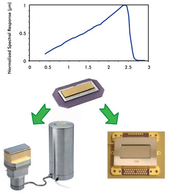
Figure 4. Hyperspectral
imaging requires high-quantum-efficiency detectors that are large (to increase ground
projection) and that have high spectral resolution. Shown is Sofradir’s Saturn,
a visible-to-SWIR 1000 x 256 x 30-μm MCT detector available in two configurations:
Dewar/cooler for airborne applications (bottom left) and packaged for passive cooling
for space-borne applications (bottom right). Courtesy of Sofradir.
Applications vary
The number of IR remote sensing systems has increased rapidly,
largely as a result of the advances in cooled IR detector technology, including
the development of 2-D staring arrays with excellent sensitivity and reliability.
Systems based on MCT staring arrays are the most common because of their high performance,
versatility in spectral response and availability of space-qualified designs. Examples
of current and planned remote sensing instruments abound.
The Venus Express (Figure 1), a spacecraft launched in late 2005
by the European Space Agency (ESA), has been in orbit around Venus since April 2006,
enabling analysts to study the planet’s atmosphere and clouds in unprecedented
detail and accuracy. Spectroscopy for Investigation of Characteristics of the Atmosphere
of Venus (SPICAV), an onboard remote sensing instrument, uses an MWIR MCT detector
in the 2.2- to 4.3-μm wavelength range to observe the sun through Venus’
atmosphere. This perspective permits analysis of the atmosphere’s IR absorption
and reveals characteristics of the atmosphere itself.
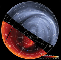
Figure 5. Using Venus Express, images at various wavelengths can
be compared, enabling the study of Venus’ turbulent atmosphere. The lower
left image shows an IR temperature map of Venusian cloud tops on the planet’s
night side, and the upper right, a UV image of the Venusian day side. The UV image
reveals the structure of the clouds and the dynamic conditions in the atmosphere,
whereas the IR image provides information on the temperature and altitude of the
cloud tops. Courtesy of the European Space Agency.
AVIRIS, a hyperspectral instrument produced in 1987 by NASA’s
Jet Propulsion Laboratory in La Cañada Flintridge, Calif., was designed to
help understand processes related to the global environment and climate change.
The optical sensor delivers calibrated images in 224 contiguous spectral bands in
the 400- to 2500-nm wavelength range. The main objective of the AVIRIS project is
to identify, measure and monitor constituents of the Earth’s surface and atmosphere.
NASA is developing an enhanced version of its MODIS (Moderate
Resolution Imaging Spectroradiometer). The eMAS (enhanced MODIS Airborne Simulator)
will be used on high-altitude research aircraft to map clouds and monitor environmental
conditions. It will perform many of the same science missions as AVIRIS (vegetation
land cover and ocean color measurement) for measuring the effects of global climate
change and improving climate models with better measured data. The quality of the
data will be improved with the help of a large-format MCT SWIR array operating in
the 800- to 2500-nm spectral band with 5-nm spectral resolution and 50-m spatial
resolution.
The Airborne Prism Experiment (APEX) was developed by a Swiss-Belgian
consortium on behalf of ESA. Intended as a simulator for future space-borne hyperspectral
imagers, it includes an MCT IR detector such as that shown in Figure 4. During extensive
tests between October 2008 and June 2009, hyperspectral data cubes were recorded
in test flights over Switzerland, Germany and Belgium in ~190 bands in the 900-
to 2500-nm wavelength range, with a spectral resolution of <1 to 5 nm and at
a spatial ground resolution of 2 to 5 m at flight altitudes of 4 to 10 km. Further
APEX campaigns are planned to gather more hyperspectral data.
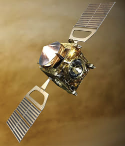
Figure 6. Artist’s impression of the ESA spacecraft Venus Express
in orbit around Venus with onboard remote sensing instruments. Courtesy of the European
Space Agency.
The Second Generation Global Imager aboard the GCOM-C (Global
Change Observation Mission) satellite was designed for monitoring global environmental
change. Remote sensors operate in the near-UV to the thermal IR to provide high-accuracy
measurements of clouds and aerosols, glaciers, snow and sea ice, as well as to monitor
earth temperature (sea and land). To perform some of the required measurements,
a customized VLWIR MCT sensor was developed by Sofradir of Châtenay-Malabry,
France, with detection in two absorption bands: 10.8 and 12 μm. The detectors
were enclosed in a Dewar and integrated with a cryogenic cooler to hold a temperature
of 55 K.
Launched in late 2009, NASA’s Wide Field Infrared Survey
Explorer surveys the sky in the IR wavelength range from 3 to 25 μm to search
for the origins of planets, stars and galaxies. The satellite includes IR detector
arrays at 3.4, 4.6, 12 and 22 µm used to create sky maps.
ESA’s Sentinel-2 pair of polar orbiting satellites, scheduled
to launch in 2013, will be equipped with a passively cooled MCT detector developed
for Earth observation by Sofradir. Based on new space-qualified MCT packaging technology,
it generates high-resolution multispectral imagery to meet the needs of operational
land monitoring and emergency services. Each Sentinel-2 satellite is intended to
carry a multispectral imager with a swath of 290 km having 13 spectral bands.
Another common use of IR remote sensing systems has been in military
intelligence satellites; e.g., in reconnaissance and intelligence gathering. Several
countries have used visible, short-wave, mid-wave and long-wave sensors on their
military satellites to gather image information about ground targets and activities
of national security significance. Many of the satellites deliver superior resolution
when compared with nonmilitary systems.
Meet the author
Dr. Frank J. Vallese is president and chief technical officer
of Sofradir EC Inc. in Fairfield, N.J.; e-mail: [email protected].