Europe’s nature protection areas – part of a comprehensive ecological network called Natura 2000 – cover almost one-fifth of the European Union. Such areas must be regularly monitored and evaluated to ensure preservation of natural resources and wildlife. But that isn’t easy from the ground or even with traditional aerial photography.
Now researchers at the Vienna University of Technology (TU Wien) are developing a surveillance method that will allow comprehensive and more effective monitoring from the air.
The new method involves an airplane flying at altitudes of 500 to 2000 meters, scanning strips of land that are 300 to 800 meters wide. About 10 points per square meter are sampled using rapid IR laser pulses that are sent to the ground, where they are reflected and then return to the plane. The exact distance between the plane and the ground can be calculated based on travel time, enabling the creation of a detailed 3-D map
of the landscape.
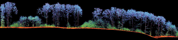
This 3-D image of a forest was generated from laser data collected using a new aerial surveillance method based on rapid IR pulses.
Courtesy of TU Wien.
Special classification software, also developed by the TU Wien team, uses the collected data to identify map features such as types of vegetation and even unauthorized vehicle tracks. Unlike aerial photography, which scans only the top of the landscape, the new observation method can image down through all layers of vegetation, from the treetops to herbs and grasses.
“Our approach is quite different [from traditional methods],” said TU Wien professor Norbert Pfeifer. “We use the data to calculate precisely the same parameters as they are collected in a site inspection by human ecologists.”
The researchers tested their computer algorithms within the nature protection area at Ágota-puszta in Püspökladány, Hungary, where an intricate mosaic of salt meadows, loess grasslands and marsh areas exists. Field data was used to adjust the algorithms, and the remaining data ultimately validated the new method’s effectiveness.
“We achieved an agreement of 80 to 90 percent between our data and on-site observations,” Pfeifer said. “This is a huge success. It is about the same level of agreement that would be expected if two different people assess the same region.”
He noted that given the early success of the new surveillance method, scientists should be able to advance it in the future.
“We believe that an even better characterization of a region’s biodiversity can be obtained when we do not focus on site inspection parameters but rather try to define new parameters which are easier to obtain from above,” he said.
The research was conducted as part of ChangeHabitats2, an EU-funded project.