Brent D. Johnson, Senior News Editor
Four days after the World Trade Center was annihilated in the worst terrorist attack in history, EarthData International was capturing images and using lasers to map the devastation.
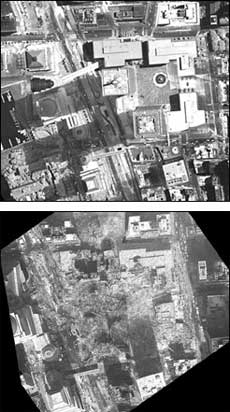
Digital and thermal cameras and lidar mapping produce stark illustrations of the devastation following the Sept. 11 terrorist attack on the World Trade Center.
At the request of the New York State Office of Technology, EarthData flew a twin-engine Navajo Chieftain carrying digital cameras, thermal imagers and lidar instruments to produce a 3-D model of the rubble.
The cameras included a 4k x 4k 16.1I panchromatic camera from Eastman Kodak Co. of Rochester, N.Y., and a NightSight Palm IR 250 from Raytheon Systems Co.'s infrared division in Dallas.
The lidar system is a proprietary instrument, positioned using a glob-al positioning system. It fires laser pulses that sweep back and forth 15,000 times per second. The laser measures five returns for every output pulse, producing elevation data that is accurate to within six inches.
According to engineer Qassin Abdullah, it works up to 20,000 feet, a great improvement over lidar systems that were only effective up to 5000 feet. He said an oscillating mirror determines the scan angle, which can reach 75° if needed.
Gas, fuel detection
EarthData officials said one of their first tasks was to detect gas and fuel that might be feeding the fires at the World Trade Center.
Before the attack, EarthData had worked with Consolidated Edison to map Manhattan's steam lines in an attempt to resolve problems the company was having with damaged insulation. By superimposing ConEd's vector data of the underground network over EarthData's thermal images, officials could direct work crews to leaks and flare-ups.
They also looked for surface deformations indicating voids or air gaps beneath the rubble where survivors might have been found.
When hope of rescue had been exhausted, the system helped to make a volumetric calculation of the construction wastes to determine whether the Staten Island landfill would be large enough to accommodate it.