Commercial satellite technology means more accurate object location and expanded spectral bands for color imaging.
Hank Hogan, Contributing Editor
If events go as planned, by mid-October a new eye in the sky will be beaming down views of the Earth that are more accurate than ever. In addition, a new generation of mapping and remote sensing satellites will carry the latest imagers. Thanks to technological improvements, the satellites will see smaller details, use more spectral bands and locate objects more accurately on the ground than current commercial systems.
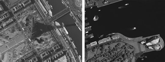
Figure 1. On a clear day, you can see Paris and Sydney, Australia — if you’re using an Earth-imaging satellite. These iconic images of the Eiffel Tower in Paris (left) and of the Sydney Opera House in Darlinghurst (right) were captured with 1-m ground resolution commercial satellites. Courtesy of DigitalGlobe.
First to fly
The first of the new mapping satellites scheduled to fly is Worldview-1 from DigitalGlobe Inc. of Longmont, Colo. (Figure 2). Within a month of its mid-September launch, the satellite is supposed to begin capturing either black-and-white or panchromatic images of points directly below it at 50-cm resolution. As it orbits at 496 km and travels from pole to pole, it will image a swath that is 17.7 km wide. The predicted accuracy with which objects can be located on the Earth — or geolocated — within those images is 3.0 m, a figure that improves by one-third if ground-based points with known locations are within the picture.
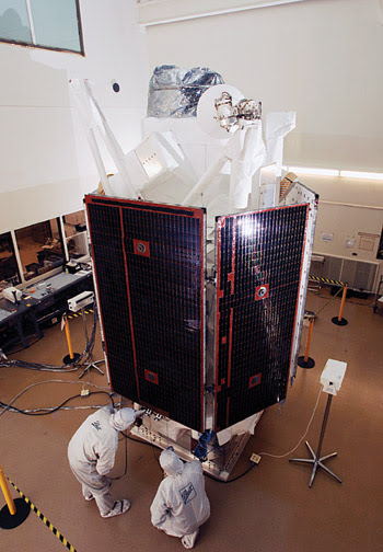
Figure 2. New satellites that will fly over the next few years, such as the WorldView satellite from DigitalGlobe shown here, promise to double the resolution and make such images even more useful. Courtesy of DigitalGlobe.
The satellite will be able to spot objects about the size of home plate in baseball, a performance double that obtainable with current systems. Chuck Herring, director of corporate communications at DigitalGlobe, noted that regulatory constraints — not technology — limit what can be commercially imaged. For that reason, he doesn’t expect to see further improvements with regard to spatial resolution anytime soon. “We’re pretty much at the threshold of where it’s going to go for quite some time.”
He does predict that mapping and remote sensing will increasingly use color. Typically, a satellite has two CCD-based focal planes. One is for black-and-white imaging and provides the highest resolution. The other is for color, with optical components separating the incoming light into different bands.
In the past, these bands have included red, green, blue and infrared channels. Some of the new satellites will offer more bands. DigitalGlobe, for example, plans to launch an eight-channel system, WorldView-2, in 2008. It will have a red edge, coastal, yellow and second near-infrared channel in addition to the traditional four. These bands, according to Herring, map well to and complement the ones used by older imaging satellites such as LandSat.
He noted that the addition of spectral bands increases the number of applications for imagery obtained with them. Agriculture, research and land-use applications all benefit from the extra information. Users of products such as Google Earth or Microsoft Virtual Earth desire images that are as true and lifelike as possible.
“The more spectral information that we can acquire in every image, the more likely it’s going to be a true color,” Herring said.
A consequence of adding color is a loss of spatial resolution. The spectral separation splits the image onto various pixels that don’t sit side by side. As a result, a multichannel imaging system has a lower resolution than a black-and-white one. From its 700-km orbit, WorldView-2, for instance, will achieve 46-cm panchromatic and 184-cm multi-spectral resolution. However, by combining color with black-and-white data on the ground, companies can deliver color data sets with the resolution of the black-and-white imagery.
Another point of view
One reason new satellites will be flying soon is the NextView program of the US National Geospatial-Intelligence Agency of Bethesda, Md. The agency is helping fund higher-resolution commercial systems to supplement information from government satellites. Along with Digi- talGlobe, GeoEye of Dulles, Va., was awarded a contract.
The latter company plans to fly its new satellite, GeoEye-1, by the second quarter of 2008 (Figure 3). As with the company’s 1-m-resolution Ikonos satellite, GeoEye-1 will fly at 684 km in a polar orbit. It will have a telescope with a 1.1-m collecting mirror, as compared with the earlier generation’s 0.70-m mirror. The larger mirror and changes in the sensor will enable the new satellite to see smaller details.
Figure 3. The GeoEye-1 is scheduled to fly by the second quarter of 2008. It will fly at 684 km in a polar orbit. Courtesy of GeoEye.
“GeoEye-1 will be able to look down on Earth with its powerful camera and see objects on the ground as small as 41 cm in size,” said Mark E. Brender, GeoEye’s vice president of communications and marketing, in describing the panchromatic resolution.
Multispectral images, collected as per NextView requirements using three bands (450 to 520 nm, 520 to 600 nm and 625 to 695 nm) in the visible and one in the near-IR (760 to 900 nm), will have a 1.65-m resolution.
The satellie’s panchromatic capability will be better than what the company’s license allows, but GeoEye reportedly is negotiating to relax this restriction.
As for geolocation, the satellite will be able to pinpoint imaged spots to within 3 m without ground control points. In the black-and-white mode, the system will collect 678,000 km3 — a bigger area than the state of Alaska — of imagery a day.
Thanks to the ability to change the satellite’s attitude, images don’t have to be taken looking straight down. The system can swivel up to 40°, allowing for a picture to be taken of New York while over Chicago and another image to be snapped a few minutes later while over New Orleans.
“What we have is a picture of New York taken from two different angles, and so we can create stereo imagery as well. We can create 3-D models of the Earth’s surface,” Brender said.
The sensors in both the GeoEye and DigitalGlobe satellites are being built by the ITT Space Systems division in Rochester, N.Y. The division, which has a Kodak legacy, also supplied the sensors for the previous systems.
Behind the scenes
The focal planes for the old and new satellites are CCD devices. However, these focal planes aren’t going into a run-of-the-mill environment, and so aren’t everyday sensors.
“Years ago, they had undergone what I would call upgrading for space, which includes additional oxide thickness for radiation purposes as well as improvements in quantum efficiency by implemen-ting indium tin oxide so we can better use the lower sources of light,” said Frank Koester, vice president and director of commercial and space sciences programs at ITT Space Systems.
The panchromatic arrays have some 44,000 8-μm-wide pixels. Thanks to the agility of the optics and of the satellite, this array can be scanned across an area of interest while the satellite flies over it at better than 7.5 km/s. The systems will be able to process some 700 megapixels of data per second in a sequence that includes compressing the data for transmission.
As with everything that goes into orbit, the focal plane and associated optics must be as small and lightweight as possible. Because of this requirement, reflective optics are used, with a primary mirror collecting the light and directing it onto a folded optical path that ends at the sensor. The sensor and optics also must be rugged enough to survive the trip into space and the seven or so years’ duration of the planned mission.
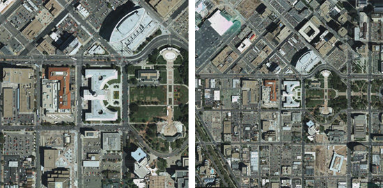
Figure 4. New commercial Earth imaging satellites will provide a close-up of the ground below. On the left is a simulated view from a next-generation satellite with a 0.5-m resolution, the current regulated limit. On the right is the same view from satellites with 1-m resolution. Courtesy of GeoEye.
The position of the satellite is fixed in space through the use of GPS and about five onboard star trackers. The combination allows the location of the satellites to be more precisely known than was possible with the old designs, which in turn enables a more accurate geolocation of imaged objects.
Koester noted that color capability was becoming more important and that the number of spectral bands was likely to grow. As for the sensors themselves, he noted that, because CCDs currently provide better quantum efficiency than their CMOS counterparts, they were more suitable for the task.
However, he said that that may not always be true and that CMOS is better able than CCDs to withstand the hostile environment of space. “One of the big advantages is their inherent radiation hardness.”However, he said that that may not always be true and that CMOS is better able than CCDs to withstand the hostile environment of space. “One of the big advantages is their inherent radiation hardness.”
For that reason, there may someday be a change in satellite sensors, he said. “We’re all going to ultimately go to CMOS devices in the future. We’re working on advanced technologies in that regard now.”
The view from elsewhere
Although companies in the US plan to launch new Earth-imaging satellites over the next year or so, they aren’t the only firms supplying commercial images. Spot Image SA of Toulouse, France, collects and sells data from a fleet of satellites. These have a maximum ground resolution of 2.5 m panchromatic and 10 m in four-band color.
Plans call for the next generation of satellites, dubbed Pleiades, to fly in the second half of 2009 (Figure 5). These systems will be smaller than previous models and may offer submeter resolution, roughly on par with the American systems.
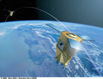
Figure 5. This is an artist’s rendering of the Pleiades Earth-imaging satellites, which should fly in 2009 and which could offer higher resolution than the current Spot series of satellites. Courtesy of Spot Image SA. Copyright 2003, CNES - Pierre Carril.
Part of the reason why Spot Image is trailing the competition is economics. Laurent Maggiori, Spot Image’s chief operating officer, pointed out that the French company, unlike its American counterparts, doesn’t have a large, guaranteed government sale for its data. Moreover, unlike in America, the satellites are owned by the government.
However, he added, there also is a technical trade-off to consider. The CCD-based sensors used by Spot Image come from EADS Astrium, a Paris-based subsidiary of the aerospace company EADS. As with all sensors, these have a fixed number of pixels. Increasing the resolution of each pixel necessarily makes the array cover a smaller span on the ground.
Without cramming more pixels into a sensor, nothing can be done about this. “It’s purely optics. It’s a compromise between the ground sampling distance and the coverage, the swath, the data you can acquire in one pass,” Maggiori said.
At 2-m resolution, Spot Image’s satellites can capture 50- to 100-km-wide strips on the ground, much broader than will be imaged by satellites with 0.5-m resolution. Part of the market wants this wider view. Maggiori said that, even if the company moves into the submeter-resolution arena, it would continue to serve the larger-resolution market and invest in a follow-on of its current fleet. As for imaging with more spectral bands, he acknowledged interest in such products but said there were no plans to deploy these systems.
On the Weather and Scientific Fronts
While new mapping satellites are getting ready to fly, the next generation of weather satellites also is under development. A proof launch of the new low-Earth-orbit National Polar-orbiting Operational Environmental Satellite System is slated for 2009, with a geostationary orbiting system scheduled to fly in 2014.
These satellites will have 16 spectral bands, more than three times the number used in the current crop. Ten channels will be in the infrared. Besides an imager, which captures pictures of hurricanes and other storms that are seen on the nightly news, the low-Earth-orbit satellites also carry a sounder. This optical instrument uses interferometry to capture hundreds of infrared channels, producing a vertical profile of temperature and water vapor through the atmosphere. ITT Space Systems builds both sensors.
The next generation of sensors is based on HgCdTe technology and captures data at wavelengths of many microns. In this range, the sensors can perform only when cooled to a low enough temperature. At times, passive cooling is enough, but active cooling is required in other circumstances. “We apply the proper technology to get the job done,” said ITT Space Systems’ Frank Koester.
As for Earth-imaging scientific satellites, the goal is hyperspectral imaging, with hundreds of bands captured within a given spectral range. One way this is done is by using a grating to spectrally separate incoming light so that one dimension on the focal plane is spatial while the other is spectral. Simply collecting an image in such an application isn’t enough. Photons must be counted so that quantitative measurements can be made.
One challenge is long-wave infrared hyperspectral imaging, covering 8 to 14 μm. The sensors must be cooled to 10 to 50 K, well below the temperature of liquid nitrogen. The optics and other components also must be cooled, although perhaps not as much.
Mark Folkman, director of sensors and phenomenology at Northrop Grumman Space Technology of Redondo Beach, Calif., said that both HgCdTe and arsenic-doped silicon are being considered for the sensor focal plane. The former is harder to fabricate but operates at a higher temperature than the latter.
Evaluation of the competing approaches is under way, but neither yet meets requirements, a fact that, in some ways, is holding back the next generation of Earth-imaging scientific satellites.
“If we could get the hyperspectral imaging technology in the thermal infrared to work today, people would want to fly now,” Folkman said.