
Seeing the fluorescence for the trees
The subtle fluorescence that plants emit during photosynthesis –
invisible to the naked eye – could provide a rapid picture of how healthy
the world’s land vegetation really is.
Using satellites – instead of the ground-based or airborne
instruments commonly used to measure the fluorescence – scientists from NASA
Goddard Space Flight Center in Greenbelt, Md., have developed global maps of land
plant fluorescence that could help identify plant life that is under environmental
stress. Sensing this fluorescence remotely – from space – could perhaps
help farmers and aid workers to more quickly address critical issues such as crop
failures and famine.
Satellites have up until now used “greenness” indicators
based on reflected light rather than fluorescence to help monitor land plants. The
problem with this method is that there is a time lag of days or weeks before a diminishing
level of plant greenness – caused by frost, drought or the changing seasons,
for example – can be detected by satellite.
Chlorophyll fluorescence enables scientists to determine immediately
whether plants are under stress before the leaves show outward signs of decline,
said Elizabeth Middleton, a biologist at NASA and part of the team that created
the maps.
The chlorophyll fluorescence from green foliage is produced at
red and far-red wavelengths. Background light overwhelms it. When sunlight strikes
a leaf, the leaf’s chloroplast structures absorb a good portion of the light
and convert it into carbohydrates through photosynthesis. About 2 percent of this
light is re-emitted at the longer, redder wavelengths.
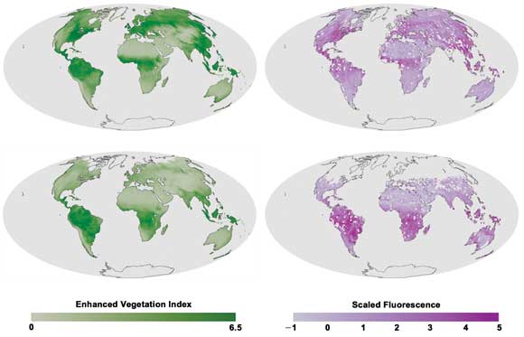
A newly developed global map of land plant chlorophyll fluorescence shows stronger photosynthetic activity in the Northern Hemisphere in July (above) and the reverse in December
(below). The data was collected in 2009 by a spectrometer aboard the Japanese satellite
GOSAT. Images courtesy of NASA’s Earth Observatory.
Scientists now can use lasers to measure chlorophyll fluorescence
across the Earth’s surface, whereas, previously, they could measure it only
on a much smaller scale.
High spectral resolution data was gathered from the Thermal And
Near-Infrared Sensor for carbon Observation – Fourier Transform Spectrometer
on the Japanese Greenhouse gases Observing SATellite (GOSAT). The researchers compared
their information with “greenness” data provided by the satellite-based
Moderate Resolution Imaging Spectroradiometer Enhanced Vegetation Index.
To make their maps, they analyzed a dark section of the infrared
portion of the solar spectrum embedded with a “Fraunhofer line.” There
is little background light at the line on which they focused – at about 770
nm – making it possible to distinguish the faint fluorescent signal.
The researchers hope that their maps will help scientists understand
carbon cycles through ecosystems.
Published: September 2011