When you think of the canal systems in the Netherlands, chances are solar panels and lidar aren’t the first things to come to mind. Instead, one might imagine picturesque scenes of waterways and beautifully distinctive architecture.
Canals have been — and remain today — an essential part of many Dutch city layouts. Originating in the 17th century, these manmade waterways led to significant economic growth. Today these channels continue to play a vital role in the country’s economy, attracting tourists and enabling commerce. But their continued heavy use has posed a challenge for canal authorities: how to monitor shipping traffic in real time and automate the opening and closings of bridges.
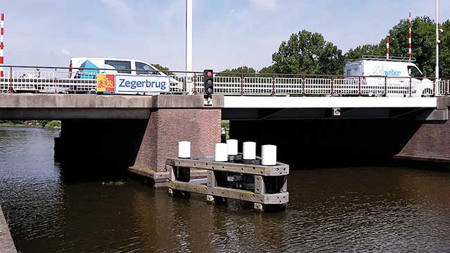
Zegerbrug Bridge, Alphen aan den Rijn, Netherlands. Courtesy of Vicrea.
The Dutch company Vicrea, known for creating integrated information systems, has teamed up with Libelium World to create a solution. The companies developed a customized wireless sensor network powered by solar panels that employs lasers to monitor the direction, distance and speed of any ship within the canals.
To monitor the shipping traffic, they used LIDAR-Lite v3 sensors. The 40-m, laser-based optical ranging sensor has an edge-emitting 905-nm, single stripe laser transmitter. The sensor can be placed anywhere depending on the needs of each canal, and detects any sea vessel that passes by.
Vicrea business consultant and architect, Erkan Efek, told Photonics Media this particular sensor was chosen for its portability.
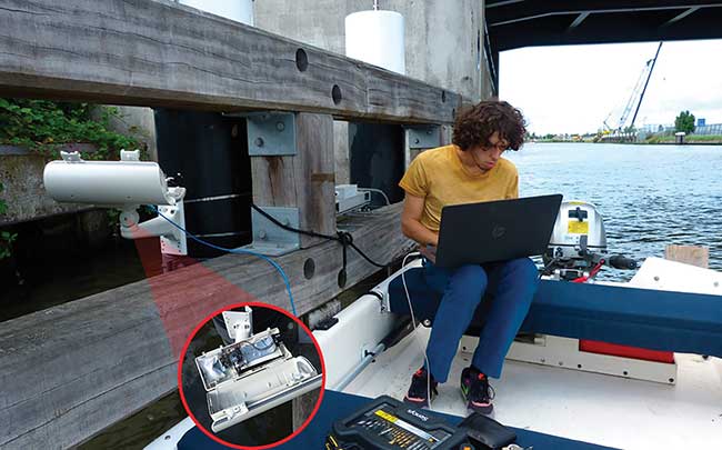
A technician programming the installation on a bridge. Courtesy of Vicrea.
“The lidar helped us to detect sailing boats and motorboats that do not use the Automatic Identification System,” said Efek, explaining the tracking system that allows vessels to electronically exchange data with other ships. “The canals are relatively small with many bridges, so the lidar was ideal to use.”
The shipping traffic data monitored by the sensors is then added to Libelium’s Waspmote Sensor Internet of Things (IoT) platform and further distributed wirelessly for analysis and prediction.
Efek said, “The data is then sold to the provinces; they use it in the Blue Wave project which involves more organizations. The [Blue Wave project’s] goal is to prevent traffic jams on the canals or roads when bridges open.”
Thus far the Vicrea and Libelium World solution is deployed in Delft, The Hague, Leiden, Alphen aan den Rijn and Gouda. The companies are discussing the solution with other provinces and with the Ministry of Infrastructure, which controls all the waterways in the Netherlands, according to Efek.
High-density shipping traffic in some of the Netherland’s most well-known and visited cities is monitored 24 hours a day, 7 days a week, ensuring smooth sailing from here on out.