Archaeologists have been using lidar to advance investigations of the past, primarily in areas where there were known large-scale civilizations in dense forested settings, such as Mayan areas in Central America and Angkor Wat in Cambodia.
For smaller archaeological explorations, most surveys are not as sophisticated and the brunt of the work has to be done on foot. In northern Michigan, for example, Meghan Howey, a researcher and associate professor of anthropology at the University of New Hampshire, has been leading students and volunteers around Douglas and Burt Lakes — near the University of Michigan Biological Station — for eight years in the pursuit of Native American cache pits.
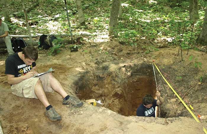
Two students mapping a pit profile to record how they were built and how they were filled in, capturing the life history of the cache pit. Courtesy of Meghan Howey.
In those eight years, Howey and her team discovered 69 clusters, typically containing 15 to 25 pits each. Lined with birch bark, these underground
“old-fashioned refrigerated” storage pits, usually three to four feet deep, were used between A.D. 1200-1600 by Native Americans in low-density mixed hunter-gatherer-horticulturalist communities.
Howey recently teamed up with Michigan Statewide Authoritative Imagery & LiDAR (MiSAIL), a program that assists the state with its geospatial data needs through high-resolution digital aerial photography.
“Working with my collaborators and developing this innovative use of lidar, we found in that same area close to 150 high-potential cache pit clusters in a matter of about a week or two of work,” said Howey.
The MiSAIL program uses a Leica ALS70-HP, high-pulse-rate airborne lidar for its topographical maps. The lidar data is computed using range and return signal intensity measurements recorded in flight, along with position and altitude measurements from an airborne GNSS/inertial subsystem.
Using the raw lidar data, the team created a one-foot resolution digital terrain model (DTM) and then innovated a suite of detection routines targeted to the cache pits. This gave Howey access to a much larger spatial scale than she was able to get as a pedestrian.
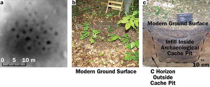
A high-resolution digital terrain model (DTM) of one previously field-identified cache pit cluster (a). A cache pit with leaf litter cleared for cross-section excavations showing current appearance of these as archaeological features (b). Cross-section excavation showing the full profile of an archaeological cache pit (c). Courtesy of Meghan Howey.
“I had always focused my survey around the high terraces near the inland lakes,” she said. “We were able to see cache pits in interesting locations away from the lakes; we would never have found these, ever, without lidar. We now have the potential to find many more cache pit sites across the Great Lakes, potentially transforming our understanding of the archaeological record of the region.”
The cache pits Howey and her team have found are primarily empty, as the native peoples would leave items in the pits while they went on hunting and gathering missions and return later to gather them. For Howey it’s not about the contents.
“This is really making us realize late precontact indigenous communities modified, shaped and engineered their landscape much more than we previously realized and they did so with a sophisticated knowledge of their entire landscape,” she said. “So while these communities may not have left a large-scale signature on the land like the Maya or such, they were constantly modifying their surroundings and we have underappreciated this fact and have much more to learn!”
Modifying her own techniques with the use of lidar, Howey plans to continue her journey across the Great Lakes.