In the event of natural disasters such as wildfires and volcanic eruptions, drones can go where manned planes can’t. In the aftermath of a catastrophe, critical air quality information is needed for deploying emergency services, evacuations and survival. A team of researchers and developers from Portugal, Sweden, Denmark, the Netherlands, Spain and Switzerland have developed the flying ultrabroadband single-shot infrared sensor (FLAIR) drone that can do just that.
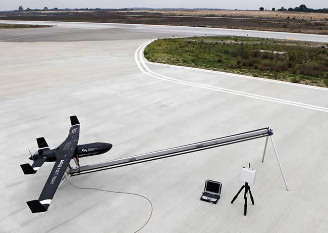
AR3 Net Ray. Courtesy of FLAIR.
The FLAIR drone is equipped with two supercontinuum laser sources in the 2- to 5-µm and the 8- to 12-µm spectral ranges. The laser sources shine across a defined spectral range as a collimated beam through a multipass gas absorption cell. The light intensity is spread out and distributed over a multipixel camera surface. The different pixel series represent different wavelengths, and within those wavelengths, molecular gas can be seen. Each gas has distinguishable absorption peaks that are defined on unique pixels.
“For the first time, a drone reaching altitudes of up to 4000 meters will be able to detect fine traces of air molecules that are dangerous to our health with a state-of-the-art laser sensor,” said FLAIR project coordinator André Oliveira of Tekever Autonomous Systems. “The drone can map out areas that are too dangerous for humans to go and can transmit data in real time to a ground processing unit.”
Standard gas sensors usually deploy light detection and ranging (lidar) or differential optical absorption spectroscopy (DOAS). The sensors focus on one or a few specific molecules, such as carbon dioxide and methane, using a narrow spectrum laser.
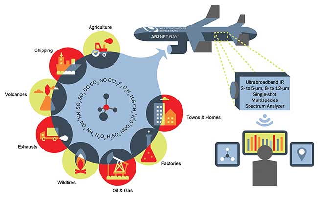
FLAIR Concept Note. Courtesy of FLAIR.
The FLAIR sensors work in a much wider spectrum, and more detailed signatures in the gas mixture can be detected, such as carbon dioxide, methane, sulfur oxides and nitrogen dioxide.
Oliveira told Photonics Media that the drone applies the latest in miniaturized, low-cost, low-weight, uncooled components and allows for the use of many components simultaneously.
“Current gas sensor technology generally relies on traditional lasers with limited tunability,” he said. “The wide spectral bandwidth of the supercontinuum source in combination with a 2D VIPA spectrometer and an innovative uncooled MWIR focal plane array means that any number of gases can be detected simultaneously and also makes the system much more resistant to interference between absorption features of different gases.”
The FLAIR team is made up of Tekever Autonomous Systems, Sensear AB, NKT Photonics A/S, the Technical University of Denmark, New Infrared Technologies SL, Radboud University, the Swiss Federal Laboratories for Materials Science and Technology and the Swiss Center for Electronics and Microtechnology.
Flying through some of the toughest environments on Earth, such as dangerous clouds or poisonous plumes, the FLAIR drone aims to provide real-time air quality data for quick decision-making during evacuations and the deployment of rapid response emergency services.