A team of researchers at Rochester Institute of Technology (RIT) led by scientist Donald Figer, are developing an image detector that is out of this world. The new Lidar (light detection and ranging) imaging detector uses light, instead of radio waves, to measure distance and other features of celestial bodies.
In conjunction with MIT’s Lincoln Laboratory, RIT’s Imaging Detector Laboratory (RIDL) is creating the optical/ultraviolet imaging Lidar detector with the hope that it will provide 3-D location information for planetary surfaces. These “roadmaps” will provide robots, astronauts and engineers details about atmospheric composition, biohazards, wind speed and temperature. Information like this could help land future spacecraft and more effectively navigate roving cameras across a Martian or lunar terrain. 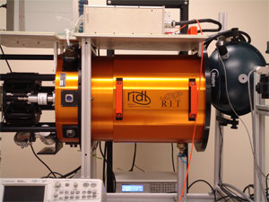
The Lidar imaging detector unit.
The devise will consist of a 2-D continuous array of light sensing elements connected to high-speed circuits.
“The imaging Lidar detector could become a workhorse for a wide range of NASA missions,” says Figer, RIT professor and director of the RIDL. “It could support NASA’s planetary missions like Europa Geophysical Orbiter or a Mars High-resolution Spatial Mapper.”
Lidar works by measuring the time it takes for light to travel from a laser beam to an object and back into a light detector. The new detector can be used to measure distance, speed and rotation. It will provide high-spatial resolution topography as well as measurements of planetary atmospheric properties – pressure, temperature, chemical composition and ground-layer properties. The devise can also be used to probe the environments of comets, asteroids and moons.
The team, consisting of Figer, Zoran Ninkov and Stefi Baum from RIT and Brian Aull and Robert Reich from the Lincoln Laboratory, will apply Lidar techniques to design and fabricate a Geiger-Mode Avalanche Photodiode array detector. The devise will consist of an array of sensors hybridized to a high-speed readout circuit to enable robust performance in space. The radiation-hard detector will capture high-resolution images and consume low amounts of power.
The imaging component of the new detector will capture swaths of entire scenes where the laser beam travels. In contrast, today’s Lidar systems rely upon a single pixel design, limiting how much and how fast information can be captured.
“You would have to move your one pixel across a scene to build up an image,” says Figer. “That’s the state of the art Lidar right now. That’s what is flying on spacecraft now, looking down on Earth to get topographical information and on instruments flying around other planets.”
The Lidar imaging detector will be able to distinguish topographical details that differ in height by as little as one centimeter. This is an improvement in a technology that conflates objects less than one meter in relative height. The Lidar that is currently used could confuse a boulder for a pebble, an important detail when landing spacecraft.
“You can have your pixel correspond to a few feet by a few feet spatial resolution instead of kilometer by kilometer,” Figer says. “And now you can take Lidar pictures at fine resolutions and build up a map in hours instead of taking years at comparable resolution with a single image.”
The imaging Lidar detector will be tested at RIDL in environments that mimic aspects of operations in NASA space missions.
In addition to planetary mapping, imaging Lidar detectors will have uses on Earth, such as remote sensing of the atmosphere for both climate studies and weather forecasting, topographical mapping, biohazard detection, autonomous vehicle navigation, battlefield friend/foe identification and missile tracking, to name a few.
RIT’s $547,000 Lidar program is funded by NASA, and includes a potential $589,000 phase for fabrication and testing.
For more information, visit:
www.rit.edu
.