As a growing number of players in the space race clutter Earth’s orbit with debris, unique methods of detecting and monitoring these objects must be developed.
Emile Beaulieu, Nüvü CamEras INC.
The space industry has undergone a remarkable transformation in recent years. Once the domain of big-budget government projects, the field has increasingly seen the entry of more and more commercial enterprises, ranging from high-profile, billionaire-funded rocket launches to small startups with innovative ideas about capitalizing on the emerging space economy. The transformation has become significant enough that many speak of a “NewSpace” era.
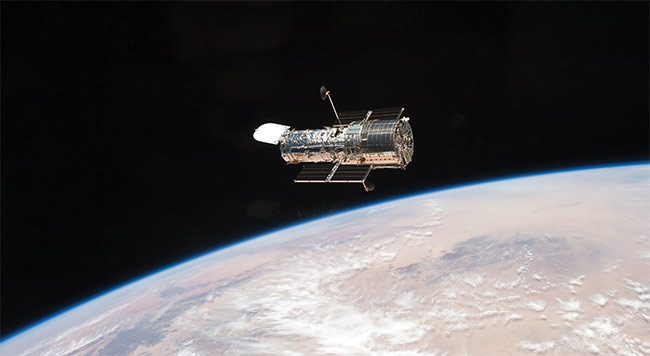
Often traveling at kilometers per second, space debris can cause significant damage to valuable space assets, such as the Hubble Space Telescope, which showed evidence of hundreds of impacts after only two years in orbit. Courtesy of NASA.
One chief driver for this revolution is the emergence of nanosatellites. Weighing between 1 and 10 kg, nanosatellites’ small size helps to minimize development time and fabrication cost and allows
several satellites to be deployed at once from a dedicated launch. This has resulted in reduced launch costs and contributed
to the proliferation of expansive networks, or constellations, comprising dozens of satellites that enable unprecedented
sky coverage and new application possibilities.
Key applications driving the deployment of nanosatellites include quantum-secure communications for internet and telecommunications networks, agricultural monitoring and security and defense via Earth observation platforms, and, increasingly, space debris monitoring.
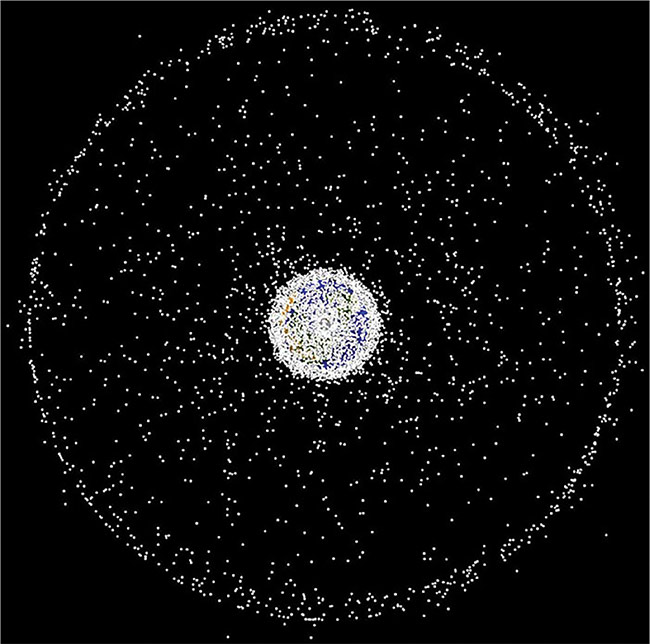
A computer-generated image of space debris currently being tracked. Millions of pieces of debris remain undetected. Courtesy of NASA ODPO.
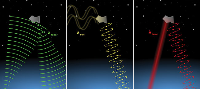
Space debris and meteors have high angular speed, which presents challenges when these objects are imaged from the ground. Their speed gives a camera pixel very little time to collect a signal and often requires the use of supplemental space domain awareness techniques. In addition to optical imaging (center), radar imaging (left) and lidar (right) are also used to detect the debris. Courtesy of Nüvü Cameras.
Space debris monitoring might be considered by some to be an outlier application because it does not directly benefit a specific industry. However, as space-based technology becomes increasingly critical to our lives and prevalent in Earth’s orbit, space debris monitoring is becoming pivotal for protecting spaceborne investments and helping to keep them operational.
Cluttered space
Space debris began to accumulate with the first space launches and, while the size of a rocket can seem insignificant in relation to the vastness of Earth’s orbit, NASA estimates that over 500,000 pieces of debris larger than 1 cm are now circling Earth at speeds of up to several kilometers per second. Because over
4000 operational satellites share this orbit, and further explosive growth in nanosatellites is forecast for the coming years, space will become increasingly crowded.
With debris traveling at such velocities, pieces measuring only a few micrometers wide are big enough to cause significant damage to valuable space assets. Studies
of the Hubble Space Telescope’s solar panels revealed hundreds of impacts with such debris after only two years in orbit. These impacts reduced the panels’ ability to generate energy.
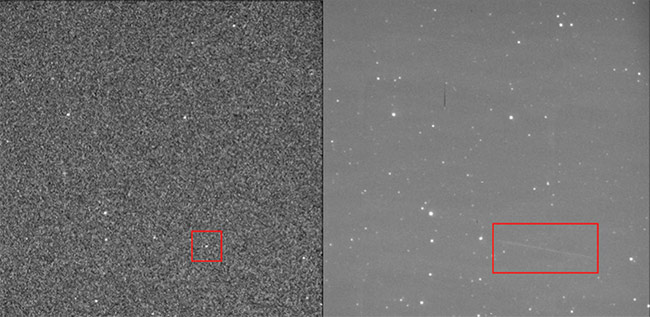
Typical results obtained by a staring imager when it is applied to space debris detection. A short exposure shows debris as a speck (left), whereas a long exposure shows it as a streak (right). The streak is fainter than other objects due to the accumulation of noise from the background. Courtesy of Nüvü Cameras.
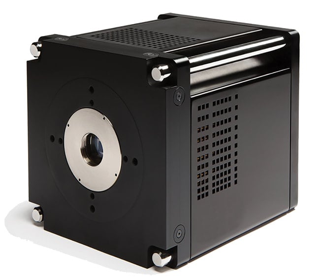
Electron multiplying CCD cameras, which helped to revolutionize ground-based astronomy over a decade ago, are now introducing new capabilities for space debris monitoring. Courtesy of Nüvü Cameras.
Another risk is that large-scale collisions could generate further debris that may cause subsequent collisions, leading to a chain reaction, with possibly catastrophic consequences for the space industry and all the applications that rely on orbital assets. Preventing collisions is the main goal of the space debris monitoring field.
Mitigating these risks by physically removing debris might seem like the most straightforward solution. However, while several ongoing projects share this goal, removing debris involves many difficult challenges. Notably, since no ground-based precedent exists, testing potential solutions can be a complex endeavor. Moreover, removing hundreds of thousands of small objects from orbit involves significant budgetary considerations, along with complicated legal considerations surrounding the ownership of the space clutter.
Even before such solutions are up and running, the debris to be removed from orbit must first be identified. Detection
and monitoring are crucial steps in this
process and have thus become the baseline approach to dealing with space debris. By cataloging the orbits of debris objects, monitoring platforms can anticipate potential collisions and direct active orbital platforms to take evasive maneuvers.
One example of such maneuvers involves the International Space Station, which has had to move out of the way of debris a total of 29× since 1999 — with three of these maneuvers occurring in 2020 alone.
Space domain awareness
Although the first ground-based observations of space predate the first rockets by centuries, tracking debris presents unique challenges that even cutting-edge modern telescopes struggle to meet. These challenges have prompted the emergence of an area of study called space domain awareness, which involves satellite and debris monitoring, and supports current space operations.
Compared to celestial bodies that appear relatively static in the sky, orbital debris can quickly move past the field of view of an observatory’s fixed telescope. Space debris detection requires a new approach, especially when searching for uncataloged objects of unknown size, velocity, or location. Debris also has unpredictable trajectories and must be monitored frequently to ensure that it has not been influenced by collisions with other uncataloged objects.
One of the challenges of monitoring objects such as debris or meteors is that these objects have high angular speed, said professor Peter Brown at the University of Western Ontario. The dwell time of such objects on a single pixel is very short compared to that of celestial objects that are imaged using conventional telescopes. Consequently, this fast movement requires collecting many images, which makes for large data volumes and unusual processing demands.
Debris monitoring can be performed using space domain awareness techniques such as radar imaging, optical imaging, and lidar. Radar has a significant advantage over the other two techniques because it is not influenced by optical conditions such as atmospheric wind currents and cloud coverage. It can also operate during the night or day. Radar, however, needs to output a source signal that is reflected on the object. This signal must reach the object with sufficient strength to be detected back at the point of origin, which limits its range. Therefore, radar is used mostly to track objects in low Earth orbit.
Compared to optical wavelengths, radio waves are on much longer wavelengths and thus have a significantly higher diffraction limit. This inherently limits radar’s resolution and enables the detection of only larger objects, though some acquisition strategies can enhance radar’s resolution past its diffraction limit.
Another approach to space debris monitoring uses optical imaging. By detecting sunlight reflected off debris, telescopes can detect objects farther away than radar can. Imaging at optical wavelengths also provides better resolution compared to radio waves. While the optical signal reaching an Earth-bound imager can be adversely affected by numerous environmental factors, corrective methods such as adaptive optics can significantly reduce the effects caused by these conditions, though such methods will never entirely eliminate them.
Lidar, however, uses the retroreflections of a laser to optically identify objects. While this avoids reliance on capturing the sunlight reflected off debris, lidar suffers from range limitations similar to those of radar and is affected by the same environmental factors as optical imagers.
By combining the data collected from these various imaging techniques from observatories spread out across the world, multiple government-funded public agencies, such as the U.S. Space Surveillance Network and the European Space Agency’s (ESA’s) Space Situational Awareness Program, are currently monitoring orbital debris. Despite these efforts, spaceborne fragments measuring between 1 and 10 cm remain too small to be detected from the ground using current technologies.
The ESA has currently cataloged about 29,000 pieces of debris to date. While this provides decent coverage of the estimated 36,500 objects larger than 10 cm in Earth’s orbit, it leaves nearly 1 million smaller objects unaccounted for. Each of these undetected objects has enough energy to incapacitate a satellite upon impact.
Identifying new debris
Each debris detection method presents its own challenges, and optical imaging is no different. When searching for new objects, the typical procedure is to use a staring CCD imager that will continually monitor a portion of the sky.
Most of the system noise in a CCD camera occurs when the image is being read out — hence the term readout noise. Consequently, long exposures are required to increase the signal per readout. As a result, the CCD must be deep-cooled to avoid the accumulation of thermal noise. In the resulting images, debris appears as streaks in the sky, which distinguishes it from comparatively stationary celestial bodies.
While straightforward, this detection method has significant disadvantages. The signal streak created by the debris is spread out over multiple pixels, each of which contains its own sky background noise. In contrast to the image signal, which only registers in each pixel for a fraction of the total exposure, this sky background noise accumulates for the entire exposure. As a result, the detection’s signal-to-noise ratio (SNR), a crucial indicator of a measurement’s quality, will decrease with an increased exposure time. Once the SNR dips too low, identifying the object becomes impossible.
This low SNR introduces limits to the smallest objects that can be detected. Smaller pieces of debris reflect less light and thus appear fainter. So, a more suitable method for identifying small debris is to use many short exposures. With multiple acquisitions, the signal is kept in a single pixel in each image, thus limiting the contributed signal from the zodiacal background.
Unfortunately, capturing images from a spaceborne platform requires more than launching a conventional ground-based imager into orbit. Designing instruments for space presents its own challenges.
During post-processing, algorithms identify the movement of these smaller items of debris and combine multiple images to produce a higher-quality result. This method increases SNR linearly as exposure time increases. However, short exposures reduce the signal per image, which means that readout noise has a significant impact on the acquisition. The readout noise must be low enough to resolve the object in each image, even with shorter exposure times.
Traditional CCDs fail to meet these performance requirements, which necessitates the use of more-sensitive imaging technologies, such as ultrasensitive electron multiplying CCDs (EMCCDs) paired with adaptive optics. Even when using such ultrasensitive technologies, identifying an object a few millimeters wide through the atmosphere from a distance of kilometers away is not yet possible.
These challenges explain why space-based observations have increasingly become part of the solution for accurately cataloging and tracking debris. With space-based imaging, the atmosphere
no longer factors into the observation equation. Removing the adverse effects caused by Earth’s atmosphere can be
extremely advantageous when capturing images of space-based objects because doing so often enables capabilities that are otherwise unachievable on the ground, according to Leon Harding, research associate professor at Virginia Tech’s Center for Space Science and Engineering Research. The trade-off when using spaceborne instrumentation, however, is that it is more costly and presents design challenges specific to operating in the space environment. Despite these caveats, Hubble’s enduring legacy showcases the power of space-based instrumentation.
New frontiers
Unfortunately, capturing images from a spaceborne platform requires more than launching a conventional ground-based imager into orbit. Designing instruments for space presents its own challenges due to the harsh conditions of launch and the difficult operational environments above Earth’s atmosphere. Camera electronics lacking a proven track record that has been established via multiple space missions must be qualified by undergoing a long testing process. They must also be designed with operational redundancies and to accommodate the high levels of radiation in space.
Space-qualified parts are significantly more expensive and are based on older — albeit more proven — technology, which often means they are substantially less effective than current but less proven technology. As a result, even the latest space instruments are based on decades-old technology.
The risk-averse mindset behind the continued use of older, more proven technology is understandable for government-funded projects that can cost billions of dollars. More cost-effective nanosatellite missions, however, have accepted higher levels of risk to accommodate smaller budgets, enabling the use of more cutting-edge components. Low-cost nanosatellites, therefore, provide the ideal platform for integrating and driving innovative technologies.
The increase in nanosatellite missions has had a significant impact on space-based imaging technologies. For example, conventional CCD detectors have been the primary choice for space-based imaging devices for many years — despite their severe limitations in sensitivity and imaging speed. But this has changed with the NewSpace dynamic.
The EMCCD is a viable new option in the space market, as evidenced by its inclusion in NASA’s next Roman Space Telescope mission set to launch later this decade. EMCCD technology — which shows a lot of promise, especially for space domain awareness applications — has become a prime candidate to replace CCDs in NewSpace missions as well.
Thanks to EMCCD cameras’ single-photon sensitivity, they helped to revolutionize ground-based astronomy over a decade
ago, notably with their ability to use shorter exposures to identify smaller space debris and fainter celestial objects. Now, EMCCDs offer new capabilities for spaceborne instruments, presenting a promising solution for nanosatellite-based imaging of extremely small and fast space debris.
Private space
The ability of private entities to launch their own spaceborne imagers would have been inconceivable several years ago. But advanced imaging and the proliferation of nanosatellites has led to a new commercial space-based business ecosystem. This ecosystem has spurred a global realization of the importance
of monitoring space debris to protect orbital infrastructures.
Several private companies are positioning themselves to
provide space tracking solutions through space-based imaging. The data provided by such companies would allow customers to learn more about the space environment and gain a better understanding of the risk factors that orbital debris poses to their missions. Such data could also provide assurances to customers’ financial backers.
This business model has its challenges — one is that governmental institutions already provide some free cataloging data on larger debris. Moreover, no catastrophic space collisions have occurred yet. And without a large asset loss, many stakeholders continue to ignore the space debris issue rather than invest in prevention.
Pioneering technological solutions could still pay off in the long run, since companies willing to innovate will be the first in line when the higher market demand for monitoring systems arises. Also, these frontline risks aren’t borne by a single company. Early monitoring projects have resulted from collaborations among a variety of private companies, all of which have
either commercialized their own space solutions or developed the electronics expertise necessary to custom-design components of debris-monitoring instruments. As the industry and its diverse actors continue to develop and expand, space debris monitoring will no doubt become one of many new space-based services that will bloom in the coming years.
Meet the author
Emile Beaulieu is an applications scientist at Nüvü Cameras Inc. He received a Master of Science degree in engineering physics from Polytechnique Montréal and has a passion for optics. Beaulieu’s areas of expertise include photonics, optical design, image processing, and biomedical imaging; email: [email protected].