Investigators are using a variety of tools and techniques to find and characterize ancient materials.
Hank Hogan, Contributing Editor
Even by the standards of his day, the fictional archaeologist “Indiana” Jones lacked the proper tools. It is hard, after all, to carefully dig up a shard of pottery and gently brush away dirt from it using a bullwhip. Nonetheless, a more accurately portrayed — albeit less swashbuckling — archaeologist might have performed his job a century ago not much differently than modern investigators, according to Thomas E. Levy, professor of anthropology and Judaic studies at the University of California, San Diego. “We still excavate like our 19th-century predecessors — with shovels, picks and trowels.”
But that tells only part of the story of modern archaeology. “The revolution that has really happened over the last 10 years is the application of this wide range of digital technology, from surveying to digital photography to remote sensing,” said Levy, who is developing digital archaeology tools with the university’s California Institute for Telecommunications and Information Technology.
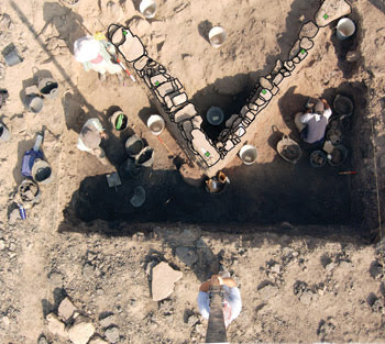
The ultimate result of digital archaeology is shown in this geographic information system drawing that is superimposed over the photograph. Photograph by Thomas E. Levy, University of California, San Diego, Levantine Archaeology Lab/Calit2.
Today, researchers digitally record data using cameras and rangefinders and combine that data with location and remote-sensing information to produce more complete pictures of the past. At the same time, advances in infrared, visible, ultraviolet and x-ray imaging are revealing previously hidden details about objects.
Levy, who identifies himself as a conventional dirt archaeologist, has been working with others from the university and with Mohammad Najjar of the Department of Antiquities of Jordan in Amman on the site of the biblical city Edom in southern Jordan. The study is part of an ongoing investigation into the role of metal production within various societies. The span in which the researchers are interested ranges from early mining in the Neolithic era about 9000 years ago to the rise of the first state-level societies during the Iron Age, which was about 1200 to 500 years before the Common Era (B.C.E).
As in times past, this has meant digging up artifacts. The modern additions to this practice include the surveying, recording and photographing of relatively small artifacts as well as large buildings.
Because of the application of digital technology, Levy noted, archaeologists need not wait until they return to a laboratory to interpret their results. “We are able to study the distribution patterns of those artifacts in real time, essentially.”
Archaeologists working on a site record data in multiple ways, the most basic being the imaging of objects. Various additional data are attached to the image, including a classification of the artifact type; for example, it might be noted that it is a hammer stone used for making stone tools. The information about an artifact also includes its X-, Y- and Z-coordinates, derived either from global positioning system (GPS) data or from other digital surveying technology.
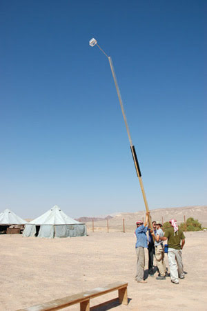
Students lift a 7-m-long wooden boom with an attached digital camera to take georeferenced photos of an Iron Age excavation site in Jordan. Photograph by Thomas E. Levy, University of California, San Diego, Levantine Archaeology Lab/Calit2.
The same approach, but on a series of progressively larger scales, is used to place the artifacts into a broader context. For instance, the university investigators start the process by getting a bird’s-eye view, using a handmade boom that enables them to raise a lightweight digital camera, with about four megapixels, to a height of about 5 m. From that vantage point, they shoot pictures of the excavation area. The benefit of this approach is that it permits them to capture what is going on at the site, recording where various objects are in relation to each other and to larger objects such as the walls of a building.
Because of the camera’s height, images can be collected over a wider area than is possible with a handheld mount. With the vantage point known via GPS or other means, the images provide a way to locate and map the various artifacts. The photographs also help locate the rocks that make up the ancient walls, thereby allowing the construction of highly accurate maps. Combined with imaging of the surface topography of the site, that data allows the accurate placement of artifacts within the work area. “The recording of each artifact at subcentimeter accuracy is done with the surveying instruments,” Levy said.
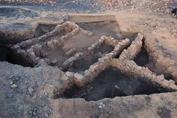
An overhead view shows the complete excavation of a building at Khirbat en-Nahas in Jordan, the largest Iron Age copper factory in the Holy Land. Photograph by Thomas E. Levy, University of California, San Diego, Levantine Archaeology Lab/Calit2.
Levy also wants to put the information into a really big context through the creation of the Digital Archaeological Atlas of the Holy Land. Still in the preliminary stages, the atlas is slated to cover all sites in the region, spanning prehistoric eras through 1918, the beginning of modern political history in the area.
Mapping the Holy Land
Just as imaging has benefited from the advent of digital technology, so, too, has mapmaking. Modern geographic information systems overlay map data with information such as the location of roads, pipelines and other infrastructure. These data are treated by software as layers, so that system users can highlight areas where two sets of items — roads and pipelines, for example — intersect.
Archaeologists are turning to the same technology, creating databases where information on sites is placed on a map. They have developed data for sites around the world, and the atlas project is one effort to tie the data together. The data can originate from projects such as Levy’s or from images taken from space, which is the logical extreme of gaining height to see more.
Satellite imaging and other remote sensing offer advantages, particularly given the size of some archaeological sites. An entire site may be too big to capture in a single image from any location on the ground, but a complete picture can be easily obtained from orbit.
That complete picture may even include all of the sites within a region. At Arizona State University in Tempe, Stephen H. Savage directs the Geo-Archaeological Information Applications laboratory. Using geographic information system, database and Web technologies, Savage and his colleagues have created Jordan Antiquities Database and Information System (JADIS).
The system uses Google Maps for satellite image support, online digitizing and spatial search creation. The use of commercial technology to support satellite images frees those working in Savage’s laboratory to turn their attention elsewhere. “We can concentrate on the archaeological data,” he said.
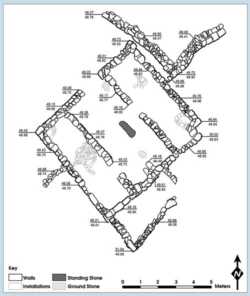
This is the final plan of the Iron Age copper factory at Khirbat en-Nahas. This map makes use of georeferenced boom photographs. Photograph by Thomas E. Levy, University of California, San Diego, Levantine Archaeology Lab/Calit2.
Users can select a search area and find all sites within a kilometer of that section, thus creating a powerful planning tool for archaeologists and others. The information provided by the system is two-tiered, with nonsensitive information public. Site locations, maps and the ability to add or change records are limited to licensed users.
The system can link digital photographs as well as scanned and digital documents to site records. Some image processing is performed, but Savage indicated that it is minimal and happens after digital images — the originals of which are maintained by the image provider — are uploaded. “We crunch them to a standardized size and create a thumbnail and store them.”
The Digital Archaeological Atlas of the Holy Land will be an extension of the Jordanian model to cover the area of the eastern Mediterranean known as the Levant. It should provide a way for researchers to study activities such as trade by drawing a boundary around a set of sites to model trade networks. The information also could be used to plan modern infrastructure by showing not only where sites exist but also where archaeological searches have or have not taken place.
You are there
Although of professional interest, such digital data also could benefit members of the public. Well-known and frequently visited historical and archaeological sites, for example, feed the public’s curiosity by showcasing select items in a nearby visitors’ center or by lending pieces to museums. Another possibility would be to take archaeological information and enhance it, resulting in an immersive experience.
“I call it ‘there-reality’ — creating the same perceptual experience as if you were actually ‘there’ in the real scene being portrayed,” said Alan G. Chalmers, a professor of visualization at the University of Warwick in the UK.
Chalmers is leading a group that is attempting to re-create three-dimensional scenes that are faithful reproductions of archaeological sites, primarily as a tool for professionals to explore the past with confidence. He noted that identical methods could be used for both education and exhibits.
A feasibility study of such techniques is just wrapping up, with the goal of re-creating the inside of a Byzantine church in Kiti, Cyprus. Such churches are thought to be good test cases because of the way in which architectural features, gold, natural light and candlelight were used to create visual effects that observers find moving. For example, in these churches, pictures of Christ, the Virgin Mary and the saints seem to be illuminated from within, a visual experience that has a profound effect on worshippers that is difficult to duplicate.
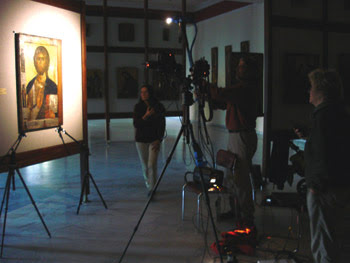
Researchers are shown collecting data from a 12th-century icon of Christ at the Byzantine Museum and Art Galleries in Cyprus. Eventually, the data will be used in a digital reproduction of the image using a high-dynamic-range display. Used with permission of the Archbishop Makarios III Foundation, Nicosia, Cyprus.
In its feasibility study, the group employed high-dynamic-range displays made by BrightSide Technologies Inc., which was recently acquired by Dolby Laboratories Inc. of San Francisco. The displays provide 200,000:1 contrast ratios and are brighter than conventional flat panel or CRT displays by an order of magnitude.
Combining technologies
Behind this performance is an array of high-brightness white or tricolor LEDs. Acting as the backlight for the LCD panel, each LED controls part of the display and can be manipulated individually at faster than video refresh rates. The observed performance results from the combination of LED and LCD technologies.
Chalmers noted that the high brightness and high contrast of the displays made a major difference in the perception of the computer reconstruction. He added that the most technically challenging aspect of the project involved capturing the images and other data; the next most challenging was modeling accurately how light interacted with the various surfaces and features.
However, he does not think that sight alone will be enough, either for lay audiences or for professional archaeologists. “Future work will investigate, including sound, temperature and even smell. A person’s experience of a site is not only the visuals — we need to provide a multisensory virtual environment.”
Picking the right spot
Although the focus is on advanced imaging and display technologies, simpler techniques also can benefit archaeological studies. Christel M. Baldia, a former assistant professor of textiles at Florida Institute of Technology in Melbourne, collaborated with Kathryn A. Jakes, a professor of textile sciences at Ohio State University in Columbus, in a study of ancient textiles.
The colleagues made use of existing forensic photography techniques, film cameras and a variety of filters to obtain visible, UV-reflectance, UV-fluorescence and infrared images of textiles that were found at sites in eastern North America. Such textiles now are largely devoid of color, with whatever pigments that were originally present having faded away. As a result, researchers in the past would have discarded the material as being of no value, whereas identifying the sources for the various colorants could yield valuable information. “We can learn about the development of prehistoric textile technology, colorant use, and utilization of the environment and trade relationships by prehistoric peoples in eastern North America,” Baldia said.
She noted that forensic photography was only part of the analysis protocol established. The other techniques involved sampling and, thus, some destruction of the fabric. The objective of the researchers was to get the most data with the least harm to the irreplaceable objects; for that, they needed to know precisely where to sample.
The researchers first created replicas of the textiles, fabricating these with techniques and dyes thought to be the best mimics of those used to manufacture the originals, based on ethnographic evidence and records of encounters made by early travelers. After determining which of the various wavelengths did the best job highlighting areas of interest in the test samples, they applied the same techniques to textile specimens from the Hopewellian Seip burial mounds of southern Ohio. Examination of these more than 2000-year-old textiles under various illumination sources revealed patterns that pinpointed where sampling would be most effective.
Baldia cited cost as the chief reason why they used film and not a digital camera. She also noted that the application is new, but that the techniques are not. “It has been done before in different contexts,” she said, pointing to the use of forensic photography to get fingerprints or trace evidence; museum staffs also use it to detect forgeries in paintings. “It just was not applied to archaeological textiles before.”