
Army Tests Lidar Geo-Mapping at Fort Leonard Wood
FORT LEONARD WOOD, Mo., Sept. 21 2021 — 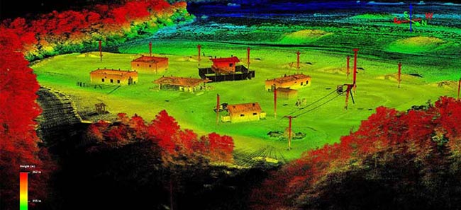
A high-resolution, survey-grade 3D map of Range 24 at Fort Leonard Wood created using lidar. The army is considering augmenting its mapping technology with lidar, which could save time and decrease risk to personnel. Courtesy of U.S. Army.
Representatives from the National Geospatial-Intelligence Agency research team in St. Louis met with U.S. Army Training and Doctrine Command Proponent Office Geospatial (TPO-GEO) service members and civilians during Army Engineer Regimental Week to demonstrate lidar survey data collection capabilities.
The Army is considering augmenting its mapping technology with lidar, and the proof-of-concept demonstration, which took place last month at Range 24, offered Army Geospatial officials a chance to see it in action, according to 1st Lt. John Fangmeyer, a geospatial development officer from TPO-GEO.
Range 24 was selected because it has infrastructure — buildings and machine gun emplacements — as well as open areas with differences in elevation, Fangmeyer said.
“This allows for a diverse environment to be surveyed that will provide a good test for the capabilities of lidar and the collection platform,” he said.
Richard Manning, a geospatial analyst with TPO-GEO, said lidar could also save time in the data collection process. “In the case of complex structures, what would take a week in the past (with traditional surveying methods) can take minutes with lidar,” he said.
Lidar technology can also provide a safer collection method that wouldn’t require soldiers to place themselves in harm’s way, a press release from the Army (Fort Leonard Wood Public Affairs Office) said.
Once data is collected, it must be processed. Army personnel were present for the tests to analyze the data and turn it into “products” that the Army could use.
Final product creation and analysis determined the accuracy of the collected data to be well within the accuracy standards in comparison to the conventional surveying methods currently in use, Fangmeyer said — though the collection could be done in a fraction of the time and with fewer people.
“Using conventional methods, the same survey was estimated to have taken approximately two weeks using four personnel,” he said.
Published: September 2021