
CHRSE Partnership Created by Headwall, Geo-konzept
Headwall, a designer and manufacturer of complete spectral instrumentation solutions for remote sensing and advanced machine vision, and geo-konzept, a manufacturer of GPS and GIS technologies for agriculture, announced at Agritechnica 2019 the formation of a Center for Hyperspectral Remote Sensing Europe (CHRSE).
The Headwall CHRSE will be located at geo-konzept’s headquarters in Adelschlag, Germany. The new center will support the implementation and utilization of hyperspectral imaging technology combined with other sensor technology such as lidar and high-precision GPS focusing on agriculture, mining, environmental monitoring, and infrastructure inspection applications. The facility features test areas for unmanned drone flights and certified unmanned aerial vehicles (UAV) through the implementation of hyperspectral imaging technology in application-specific environments. The center also offers indoor meeting areas for developers and researchers, and helps data analysts using hyperspectral imaging technology manage their applications.
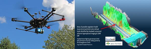
Left: Headwall unmanned aerial vehicles (UAVs). Right: Hyperspectral images capture vegetation health and location to better detect encroachment on critical infrastructure. Courtesy of Headwall.
“Our partner geo-konzept has accumulated great experience bringing multimodal sensing technology into demanding applications in the field,” said Christian Felsheim, Headwall’s European area business director. “Researchers and customers will find that this new Center for Hyperspectral Remote Sensing Europe will be a great place to develop application-relevant solutions for their needs.”
Thomas Muhr, the founder of geo-konzept, said that partnering with Headwall will provide his company with a unique opportunity to support its customers by providing them with hyperspectral imaging tools and “real-world” experience in a variety of applications in the field. “We eagerly anticipate working with Headwall as both a customer of their award-winning products and a now a partner for educating and expanding the market for nimble airborne hyperspectral solutions,” Muhr said.
/Buyers_Guide/Headwall_Photonics_Inc/c5950