Despite seven years of espionage and the offer of a $25 million reward, Osama bin Laden remains at the top of the FBI’s most-wanted list. Professors Thomas Gillespie and John Agnew and some undergraduates at UCLA recently used remote-sensing satellite imagery to track down the terrorist.
The researchers pointed out that more than 73 Earth-observation satellites were launched between 2000 and 2007. These satellites are available for use by the public – not just spies and soldiers.
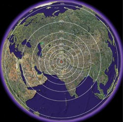
Circles of probability show where bin Laden might be according to distance-decay theory. Reprinted with permission of MIT International Review.
To the satellite images, the scientists applied distance-decay theory, which predicts that bin Laden would stay close to the place where he was sighted last and that he would be unlikely to wander into a place with a different culture or terrain. For example, he would avoid secular regions in India or Pakistan where he would be more likely to be captured or killed.
They also applied the theory of island biogeography, which originated in biology to explain the dispersion of plants and animals. If the cities are treated as “islands” for the purpose of this analysis, bin Laden probably is living in a densely populated area such as a city or large town.
Can light intensity point the way?
To determine the probable location of bin Laden according to distance-decay theory, the researchers used the equation P(d) = kd, where k is a constant, d is the distance from his last known location of Tora Bora, Afghanistan, and P(d) is the probability of bin Laden’s being located at that distance. The researchers applied this equation to create probability circles over satellite images from the Landsat ETM+ and Shuttle Radar Topography Mission, both of which were originally NASA projects.
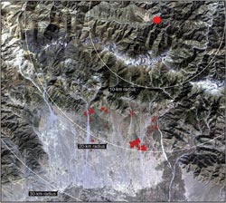
Shown are the cities that, according to island biogeography theory, might harbor bin Laden. They are located within a 20-km radius of his last known location, as shown by the red dot in the “bullseye.” Reprinted with permission of MIT International Review.
Then they used ArcGIS software with Google Earth images taken by the QuickBird satellite – owned by private company DigitalGlobe – to quantify the area of cities and the distance between them. These values were used to assess where bin Laden is hiding according to island biogeography theory.
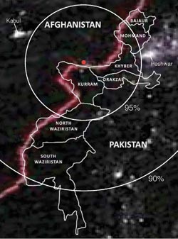
Conclusions drawn from the distance-decay and island biogeography theories were compared to boundaries of tribal regions in Pakistan and night-light imagery from the Operational Line-scan System of the Defense Meteorological Satellite Program, which was originally a joint effort of the US Department of Defense, US Department of Commerce and NASA.
Pictured is night-light imagery of the seven tribal regions of Pakistan. Reprinted with permission of MIT International Review.
Once they identified the city where they thought bin Laden is hiding, they searched the city for structures in which he would be likely to reside based on his known characteristics, including his height, the requirement for electricity to run his dialysis machine, and his needs for personal privacy and protection.
In the online edition of the MIT International Review, the UCLA investigators reported an 86.6 percent probability that bin Laden is located within the seven Federally Administered Tribal Areas of Pakistan, regions along the Afghanistan border that are said to be hotbeds of Islamic extremism out of Pakistani government control.
Of these tribal areas, the Kurram region of Pakistan had a 98 percent probability of hosting bin Laden according to the researchers. Of the 26 cities in the Kurram region, Parachinar is the largest and one of the least isolated. Therefore, the researchers believe that bin Laden is there.
They noted that the night satellite images showed the second-greatest light intensity in Parachinar, which suggests more military activity than in most other cities in Kurram, and they identified three buildings there that matched his personal requirements. The city of Peshawar had the brightest night-light signatures of all the cities in Kurram and could be a future location for bin Laden.
The researchers expressed doubt that bin Laden lives in a cave, but, if that were so, they said that they could test the hypothesis by examining the satellite imagery for signs of supplies being transported to and from said cave, such as trucks moving in and out of a region.
Got it wrong?
In their analysis, the researchers said that, to enter the Kurram region of Pakistan in 2001, bin Laden had to travel 3.1 km from Tora Bora over an approximately 4000-m pass in winter, which they admitted would have been difficult for a 44-year-old man with diabetes.
Associate professor Murtaza Haider from Toronto’s Ryerson University made a rebuttal in the online edition of the MIT International Review that Parachinar has a Shiite majority and would be unlikely to host Sunni supporters of bin Laden.
To the UCLA researchers, the main point was not whether they had gotten it right or wrong but that they objectively evaluated a testable hypothesis to find a notorious criminal.
Gillespie wrote to Photonics Spectra: “The … part about Shia and Sunni was known but was difficult to vet. Indeed our model contained no political data because we could not validate the publicly available data for the region. However, we stand by the model and our conclusions, which are (1) the model is repeatable and can be easily updated, (2) data from the US intelligence agencies from 2001 to 2006 may improve the model and (3), in order to find Osama bin Laden, our hypothesis has to be rejected by the US intelligence community or others at a global (Kurram), regional (Parachinar) and local (structures) scale.”
Haider also said that the UCLA geographers would make better use of their time studying the crisis in Darfur and not Osama bin Laden. Gillespie said, “[bin Laden] took credit for the 9/11 attacks that killed over 3000 people,” and he pointed out that Google Earth is already using satellite imagery to collect facts and figures about Darfur.
Using light signatures to evaluate the “surge” in Iraq
Did the addition of 30,000 troops in Baghdad – the “surge” – in the first half of 2007 reduce the violence there? Professors Agnew and Gillespie, along with students Jorge Gonzalez and Brian Min, studied light signatures to see if the surge “had worked,” as some had claimed. In 2008 they formally published the results of their study in the journal Environment and Planning A.
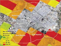
Proportion of change in nighttime lights in Baghdad before and after the surge in Iraq. Reprinted with permission of Environment and Planning A.
Political information told them that violence had been reduced in Iraq, information that was used by American leaders to assert that the surge had worked. However, the investigators wondered whether the surge had improved conditions in Iraq, something that also was implied by leaders in Washington. If the surge had improved conditions in Iraq, the investigators would have expected to see a steady increase in nighttime light output over time as the electrical infrastructure was repaired and restored.
They used nighttime images from the Operational Linescan System of the Defense Meteorological Satellite Program, as they did in the bin Laden study. They collected the images using ENVI software and Google Earth. They found that there was no change in light intensity after the surge compared with before, although the light became noticeably more intense during the surge. Therefore, they concluded that the surge had no effect in terms of improving the electrical infrastructure. They believe that declines in violence happened because of declines in population and sectarian intermixing but not because of improved living conditions.