From boosting crop yields to optimizing wind farms, lidar and hyperspectral imagers prove powerful tools in agriculture, energy and scientific research.
Thanks to advances in photonics and image processing, scientists, farmers and others can get a better picture of what’s going on across a landscape. With cameras operating over large swaths of the spectrum and lidar capturing fine structural detail, remote sensing across broad areas is increasingly cost-effective.
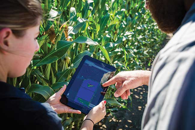
Using airborne instruments to collect remote sensing data and the proper algorithms provides farmers with plant-level water and nutrient content information, increasing yields while saving water, time and money. Courtesy of Ceres Imaging.
Data gathered with remote sensing can boost crop yields, determine where and how best to operate wind farms, and more. With better sensing and image analysis, such capabilities are becoming more powerful and useful.
And these capabilities are also growing in economic importance. Today, the remote sensing services market stands at $10.68 billion. By 2022, it will more than double to $21.62 billion1.
“The increasing use of remote sensing services in defense and commercial applications is one of the most significant growth factors,” said Amit Gulhane, analyst team leader in aviation and defense electronics at MarketsandMarkets Research.
About a third of the global market is in defense, where remote sensing is used to efficiently detect, recognize and identify people and targets of interest. The rest of the market includes users in agriculture, weather forecasting, scientific research and energy.
One of the reasons for the growth of remote sensing has been the advent of big data analytics. Collecting data over time from a large area with fine resolution leads to a mass of information. High performance and cloud computing help analyze this data from satellite-based systems, manned aircraft, drones and ground-based units.
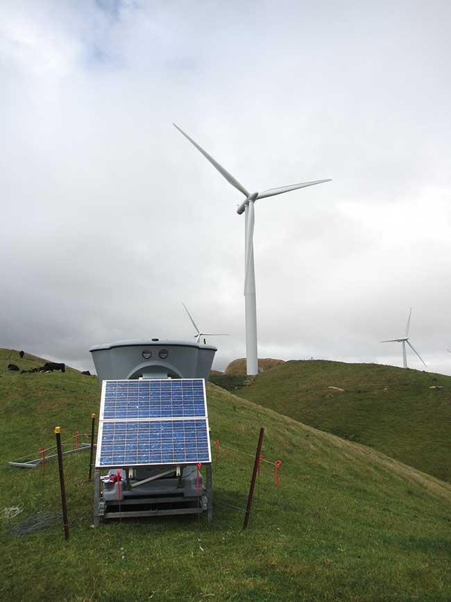
Ground-based remote sensing systems, such as this one, measure wind speed and direction, thereby helping optimize wind farm power output. Courtesy of Vaisala.
An example comes from Ceres Imaging of Oakland, Calif. Founded in 2014, the company uses remote sensing from aerial platforms to provide farmers with plant-level water and nutrient content information. The goal is to enable growers to realize higher crop yields by assessing plant health and spotting problems.
Ceres Imaging uses proprietary sensors and analytics, along with artificial intelligence technology, and according to Jamie Tolan, remote sensing scientist, the resulting images provide unmatched plant-level detail. He said growers can better optimize water and fertilizer, thereby increasing yields while saving time and money.
In part, the company is building upon work done in consumer and defense applications: For consumers, inexpensive visible and NIR cameras are available, and shortwave and thermal IR systems are much more affordable for the defense industry. Thus, it is now possible to use wavelengths from the blue at about 450 nm, through the NIR at around 1000 nm, the shortwave IR at 1500 to 2000 nm and the thermal IR at longer than 5000 nm.
Covering the complete spectrum makes remote sensing much more useful and valuable, particularly when it’s combined with expertise. According to Tolan, Ceres Imaging assembles its instrument rigs in-house, and the company tailors the software stack to the specific needs of clients. The images collected are also carefully vetted.
Tolan said having the best possible starting point for analysis is important. “Your algorithms are only as good as the raw data. You need both high-quality data to be
gin with and good analysis of the data. Better sensors are more of a limiting factor than the algorithms at this point.”
Higher resolution, lower price
The price for such systems will continue to decline while resolution increases, Tolan said. This is also the prediction for hyperspectral cameras, which enable many multiple wavelength bands to be interrogated at once. As cost comes down, the technology will become more mainstream.
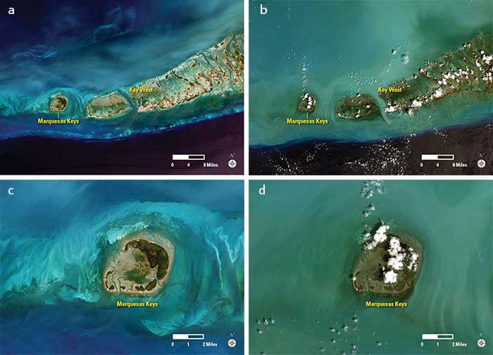
The Florida Keys, before and after Hurricane Irma in 2017. Irma churned up sediment, as shown in a larger and close up image from March (a and c) and September (b and d), which is prior to and after the hurricane. The distinct line south of the Keys where the sediment ends is a steep drop-off, the edge of the continental shelf on which the Keys sit. The dark color indicates deeper water compared to the shallower water of the shelf. Remote sensing data such as this enables researchers to study the impact of natural disasters and will be used to assess any damage that might have been done to marine habitats. Courtesy of USGS.
Jonathan Greenberg, an associate professor of natural resources and environmental science at the University of Nevada, Reno, is also hoping for a drop in the price of remote sensing data collection. Greenberg investigates the relationship between plants and their environment, and would like to see the cost of airborne lidar data collection fall. Airborne lidar, with its small-footprint instruments, offers centimeter-scale structural information and is the best way to capture data on individual trees across a wide area.
“We’d love to be able to run a California-wide analysis, mapping every tree in the state,” Greenberg said.
He added that drones are potentially less expensive to operate than manned airplanes. Thus, the cost of the instrument, as well as its size and other characteristics, needs to be compatible with these unmanned aerial vehicles.
Another needed advance is the fusing of lidar and hyperspectral instruments. The first gives structural data of a plant,
and the second yields info on its biochemistry. The result is a complete picture of what is happening in a forest or other area at the level of individual plants.
Such hyperspectral lidar systems already exist, but they are limited in number. Having more of them available and at a lower cost would be beneficial to researchers.
An innovation is the high-resolution Global Ecosystem Dynamics Investigation (GEDI) instrument, soon to be mounted on the International Space Station. An advanced lidar, it will have three lasers, each producing 3D structural data across a 25-m ground spot size. When it becomes operational in the next year or so, it will provide detailed information on forest height, canopy structure and more.
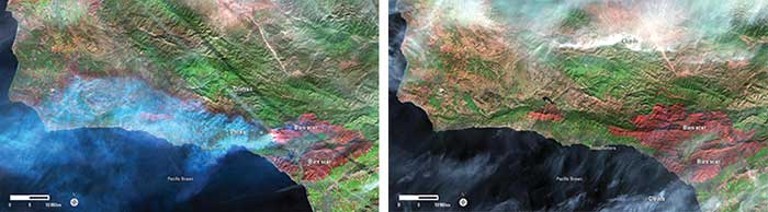
Space-based remote sensing captures images of the effect of the December 2017 wildfires in Southern California, showing the fire in progress on Dec. 9 (left) and how close it came to Santa Barbara (right) in an image captured on Dec. 25, 2017. Courtesy of USGS.
When GEDI does fly, it will join many other space-based remote sensing platforms that collect data across a spectral range, which can run from the visible to far-thermal IR. The resolution of these instruments can be as small as 30 cm. Some, such as the Landsat program, have been running for decades and have generated millions of images covering the surface of the Earth.
The choice of which data set to use and algorithms to apply depends on the problem, according to John Dwyer, chief of the science and applications branch of the U.S. Geological Survey Earth Resources Observation and Science Center (USGS/EROS) in Sioux Falls, S.D. He said that having multiple systems in orbit brings several benefits.
“It increases our probability of getting cloud-free observations more frequently, and it also allows us to capture the seasonal variability of crop types,” Dwyer said.
There is a need to adjust the measurements for the different spectral bands covered by the various instruments and account for their different spatial resolution. This is done algorithmically and results in greater coverage of remote sensing data.
According to Dwyer, algorithms are being put into place that will remove atmospheric changes. This will further improve the quality of the data and the ability of researchers to detect subtle changes in vegetation and land features.
The remote sensing data generated from above by satellites and aircraft is used in many applications, one of which is to help wind farms be as efficient in producing power as possible. Vaisala Energy, a part of Vaisala Oyj of Vantaa, Finland, utilizes remote sensing data and their more than 80 years of weather expertise to determine where wind farms should be located and the effects of local terrain, such as ridges.
For part of this data, the company uses a sound-based instrument to measure wind speeds a few hundred meters off the ground. Another approach is to use lidar, but Vaisala opted for the sonic approach because it draws less power, costs less and is more rugged, according to Lee Alnes, global manager for energy measurement systems. He said that the light- and sound-based techniques offer different strengths and weaknesses. Vaisala does use lidar in other remote sensing applications, including measuring cloud heights at airports.
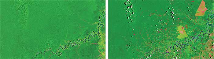
Deforestation in Peru, imaged with remote sensing. The Amazon rainforest is lush green in these images about 25 miles northwest of Pucallpa, along the Aguaytía River. Deforested land is light green or pink. The region in 1986 (left) and the same in 2016 (right). Courtesy of USGS.
When it comes to wind farms, the need is to measure wind speed and direction precisely at a given location. With today’s wind turbine hubs sitting as much as 140 m off the ground and with blades up to 70 m long, there’s a need to determine the wind speed and direction about 200 m off the ground. The traditional approach, a metrological mast, can be expensive and time-intensive. At the same time, the value of the data has grown, along with the size and number of the wind turbines.
“If you’re going to invest $300, $400 million in a wind project, you want to know year in and year out what can I expect for energy output,” Alnes said.
Enter ground-based remote sensing, which, when part of the mix with other measurements, can provide the needed data. In addition to yielding information about situating turbines, other applications are operational in nature. For instance, if the wind is in the wrong direction and at the wrong speed, the wake from one wind turbine can make the next one downstream less efficient. In that case, shutting off the downstream turbine may be cost-effective. Another operational example is that the instruments meant to align the turbine to the wind may be slightly off. Finding and fixing this error with ground-based remote sensing may yield an improvement in output of a few percentage points.
Finally, in any of the growing number of applications of remote sensing, it’s important to remember the underlying physics and chemistry that give rise to the result. This minimizes errors and mistakes.
Reference
1. A 2017 report from MarketsandMarkets Research Pvt. Ltd. of Hadapsar, India.