In situ NIRS is a vital tool for analysis of components in water and, when combined with other techniques, helps guide actions to protect natural resources.
BRIAN CURTISS, ASD INC., A MALVERN PANALYTICAL BRAND
Environmental monitoring involves the sampling and analysis of soil, water, or plants for evidence of change over time. This process informs decisions surrounding potential health risks and corrective actions. As the human population continues to grow and industrial development and energy use simultaneously rise, the likelihood of environmental damage also increases. Consequently, environmental monitoring is imperative to the protection of human health and the world.

Applying spectroscopy
Spectroscopic measurements play a crucial role in several environmental applications and serve as one of the predominate techniques for remotely monitoring Earth’s surface. Spectroscopy, the study of the absorption and emission of light (Figure 1), can be a cost-effective tool for measuring materials to optimize processes. The technique uses various wavelengths of light to identify and quantify materials. Spectroscopy makes it easier to identify raw materials as well as contaminants to determine the presence of molecular compounds, found in the water, on the ground, or in the air. Because molecules absorb light at several specific wavelengths, the absorption spectrum is often unique and works as a fingerprint to identify molecular compounds.
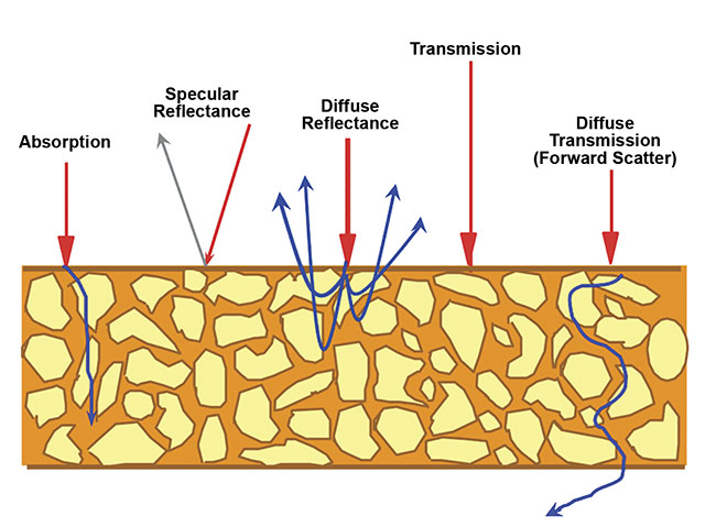
Figure 1. How spectroscopy works in environmental analysis. Courtesy of ASD.
Near-infrared spectroscopy (NIRS) makes use of the NIR region of the electromagnetic spectrum, from ~700 to 2500 nm. By measuring light scattered off and through a material sample, NIR reflectance spectra can be used to determine a material’s properties without altering the sample.
Spectroscopic measurements enable chemical and biological parameters to be measured in situ, thereby quantifying multiyear variability and indicating potential barriers to sustainable progress. NIRS is a remote sensing technique that is nondestructive; therefore, it is well suited for monitoring large regions of the environment.
Water quality parameters
Around the world, large inland water ecosystems (such as lakes, rivers, streams, and lagoons) are being affected by eutrophication, which is defined by the Oxford dictionary as “excessive richness of nutrients in a lake or other body of water, frequently due to runoff from the land, which causes a dense growth of plant life and death of animal life from lack of oxygen.” The process diminishes water quality by producing an excessive growth of algae, cyanobacteria (blue-green algae), and macrophytes. Excessively rich inland waters are a common problem in regions with agricultural activity in adjacent areas.
When entered into quantitative models, eutrophication data can be used to characterize water quality, identify trends over time, recognize emerging problems, determine whether pollution control programs are working, help direct pollution control efforts to where they are most needed, and respond to flood and spill emergencies.
Most water quality models simulate increases in eutrophication based on initial conditions of the water body. Therefore, these models demand comprehensive water quality sampling. Traditional water quality measurement requires in situ sampling and expensive time-consuming laboratory examination. Because of these limitations, sample sizes are often too small to adequately cover the entire body of water. It has also been demonstrated that the spatial and temporal frequencies of conventional water-sampling methods are too expensive for widespread investigation. As a result, the difficulty of sampling becomes a barrier to effective monitoring and forecasting of water quality.
Combining hyperspectral remote sensing and in situ NIRS provides a superior method of water quality monitoring that helps researchers overcome these constraints, especially when collecting measurements over a range of temporal and spatial scales. Numerous studies illustrate that remote sensing can meet the demand for the large sample sizes required of water quality studies conducted on the watershed scale.
For decades, imagery from satellite and aircraft remote sensing systems has been used in the assessment of water quality parameters (Figure 2), including monitoring algal blooms and surface accumulation of cyanobacteria, temperature, chlorophyll a (Chl-a, the main photosynthetic pigment in all phytoplankton), turbidity, and total suspended solids (TSS) for lakes and reservoirs, estuaries, and tropical coastal areas.
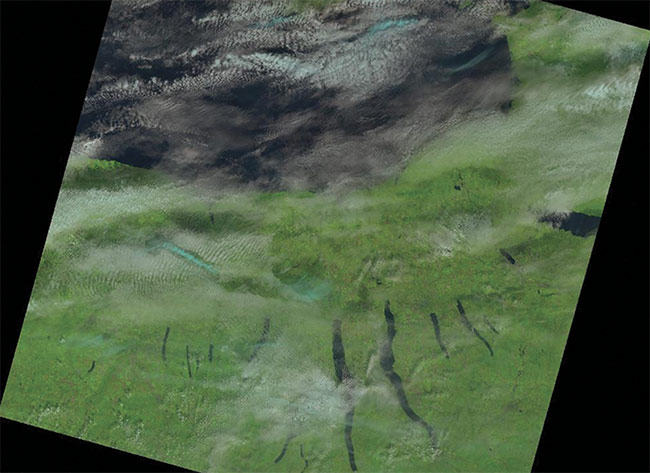
Figure 2. An example Landsat 8 satellite image capturing cyanobacteria as seen from space.
Courtesy of USGS.gov.
Monitoring the Curonian Lagoon
Algal blooms can have a negative impact on the quality and productivity of bodies of water in aquatic ecosystems and on the preservation of existing ecological balances. Some bloom phenomena can be particularly dangerous for humans and flora and fauna because the blooms produce toxins. To protect natural ecosystems, it is important to obtain a significant amount of information on the presence and intensity of cyanobacteria blooms in time and space.
Numerous studies have collected spectral data using in situ NIRS and airborne hyperspectral sensors to determine and monitor water quality parameters related to algal blooms. Several of the studies have demonstrated the capability of optical remote sensing for mapping algal blooms in marine, lacustrine, and lagoon environments. These studies have also identified bloom events in many ways: by mapping the concentrations of Chl-a, by using water transparency as an indirect parameter, and/or by using qualitative approaches based exclusively on the spectral characteristics of water (Figure 3).

Figure 3. Spectral data of algal reflectance. Courtesy of ASD.
M. Bresciani and colleagues1 aimed to monitor algal blooms and surface accumulation of cyanobacteria in the Curonian Lagoon, the largest lagoon in Europe. They combined data from the Medium Resolution Imaging Spectrometer (MERIS) with Advanced Synthetic Aperture Radar (ASAR) data. During the summers from 2004 to 2011, NIRS (collected in situ) was used to map Chl- concentrations and the presence of scum in the lagoon using two band-ratio algorithms applied to atmospherically corrected data.
The Curonian Lagoon, extending over ~1560 sq km between Lithuania and Russia, is a dynamic ecosystem. It remains very turbid due to solids (mainly sand and silt) being resuspended by local winds and intensive primary production. In the 20th century’s second half, agriculture and urban activities were major sources of phosphorus and nitrogen, adding significantly to the lagoon’s eutrophication.
The results of the 2014 study identify wind speed as the main cause of the surface accumulation of algae, as well as the spatial distribution of Chl-α. Coupling in situ NIRS measurements with MERIS images enabled researchers to implement an appropriate algorithm for monitoring the trends of Chl-a concentrations and surface scum phenomena in the lagoon waters. In doing so, the researchers ultimately demonstrated that optical and microwave signals can be used in combination to improve understanding of cyanobacteria blooms.
By interpreting the resulting classification images in the Curonian Lagoon study, the researchers were able to show that quality assessment of water bodies can be easily carried out by collecting spectra in situ and then applying algorithms derived from the collected spectra to high-resolution hyperspectral imagery. Results confirm that cyanobacteria blooms that occur in the Curonian Lagoon are characterized by complex dynamics, a marked spatial and temporal variability, and various aggregation features.
Informed decision-making
In the Bresciani study, correlations between water quality parameters and in situ NIRS data sets were identified. Using quantitative models, the spatial distribution of water quality parameter values were mapped using the hyperspectral images of the lagoon. These maps aided in the development and implementation of total maximum daily load of certain parameters such as agriculture runoff, and could identify possible causes of algal blooms in surface waters. This information ultimately enables decision-makers to determine where agricultural practices need to be changed to avoid eutrophication.
When combined with in situ NIRS, remotely sensed hyperspectral data can detect cyanobacteria blooms and scum formation; this combination of techniques could lead to better water quality monitoring (Figure 4). NIRS is vital for environmental monitoring; continued advancements in the development, application, and automation of measurement techniques are needed to enhance the accuracy and cost-effectiveness of environmental monitoring programs. Robust information delivered through a combination of measurement techniques, including remote sensing of hyperspectral imagery and NIRS, could help decision-makers determine the magnitude of environmental problems and weigh the costs and benefits of preventive and/or corrective action.

Figure 4. Ground-truthing using NIRS is an essential step for interpreting unknown materials in multispectral and hyperspectral imagery. Courtesy of ASD.
Meet the author
Brian Curtiss is co-founder of ASD Inc., a brand of Malvern Panalytical, and currently serves as ASD’s chief technical officer. He has over 30 years of experience in the fields of geology, spectroscopy, and optical remote sensing. In his current position, Curtiss applies his experience to the development of solutions to a diverse range of analytical problems in the areas of remote sensing and natural resources.
Reference
1. M. Bresciani et al. (2014). Monitoring blooms and surface accumulation of cyanobacteria in the Curonian Lagoon by combining MERIS and ASAR data. Remote Sens Environ, Vol. 146, pp. 124-135.