
Laser Maps Mars Topography Five Meters at a Time
Joseph L. Tilton
After more than 120 million measurements, the Mars Global Survey Spacecraft has given researchers more information on the topography of Mars than is known about Earth. The data -- gathered by the Mars Orbiter Laser Altimeter -- include topographical profile changes as small as 5 m.
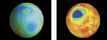
False-color topographic images of Mars' northern (Left) and southern hemispheres are green-blue below "sea level" and red above.
The altimeter was designed and built by the Laser Remote Sensing Branch of the Laboratory for Terrestrial Physics at NASA's Goddard Space Flight Center in Greenbelt, Md. The device uses a 1064-nm diode-pumped, Q-switched Nd:YAG laser from the McDonnell-Douglas Space Systems Div. in St. Louis.
At a pulse rate of 10 Hz, the instrument fires IR light at the surface of Mars and maps the planet's terrain by measuring the time it takes for the reflections to return. Each shot covers 100 m of surface, and the shots are spaced 330 m apart.
Placing the altimeter in orbit has been a saga, according to Maria Zuber, Griswold professor of geophysics at the Massachusetts Institute of Technology. The first instrument, sent in 1993, was lost three days before its scheduled arrival at Mars. The system was rebuilt in 1994-95 and launched in 1996. It began ranging to Mars in 1997, and now is the longest-lived laser ranging system in space, she said.
"We're now filling in the map with even further high-resolution observations," Zuber said. "We've been able to reconstruct directions that water used to flow on the surface as well as measure the polar caps. By combining topography with gravity data, we can map internal density changes."
Lifetime: Unknown
The polar-orbit mapping mission is expected to last until March 2001. "It could be used beyond that," Zuber said. "It is a diode solid-state laser, so we don't know how long it will last firing in the vacuum of space. For useful life, we're in uncharted territory right now."
Some places on Earth have been mapped to only within a 100-m resolution, but the Mars Orbiter Laser Altimeter will not be used to improve scientists' knowledge of our planet. Instead, the Geoscience Laser Altimeter on NASA's Ice, Cloud and Elevation Satellite will offer higher precision, Zuber said. "Around Mars, we're using 30 centimeters as the ranging precision standard. But with Earth, subcentimeter accuracy could be possible."
Published: September 1999