Faults west of Lake Tahoe, Calif., now pose a substantial increase in the seismic hazard assessment and potentially could generate earthquakes with magnitudes ranging from 6.3 to 6.9, according to a new US Geological Survey (USGS) study.
A close association of landslide deposits and active faults suggests also that an earthquake-induced landslide hazard exists along the steep fault-formed range front west of Lake Tahoe, known as the Tahoe-Sierra frontal fault zone.
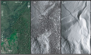
Comparison of color aerial photography with airborne light detection and ranging (lidar) imagery in an area west of Lake Tahoe, Calif. (a) Color aerial orthophoto for part of the range front along eastern base of Mt. Tallac with geomorphic features obscured by dense forest cover. (b) Same scene, first-return lidar imager. (c) Same scene, last-return (bare-earth) lidar imagery showing range-front fault scarp (between white arrows) cutting colluvium, alluvium and Tioga moraine. (Images: James Howle, US Geological Survey)
USGS scientists and colleagues from the University of Nevada, Reno, the University of California, Berkeley, and the US Army Corps of Engineers used bare-earth airborne light detection and ranging (lidar) to confirm that previously suspected faults in fact do exist.
“This study is yet one more stunning example of how the availability of lidar information to precisely and accurately map the shape of the solid Earth surface beneath vegetation is revolutionizing the geosciences,” said Marcia McNutt, USGS director. “From investigations of geologic hazards to calculations of carbon stored in the forest canopy to simply making the most accurate maps possible, lidar returns its investment many times over.”
Linear moraines (boulders, cobbles, gravel and sand deposited by an advancing glacier) were offset by motion on the faults, providing a record of tectonic deformation since the moraines were deposited. The research team created a new 3-D technique to measure the amount of tectonic displacement of moraine crests caused by repeated earthquakes.
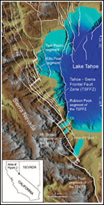
Shaded relief map of western part of the Lake Tahoe basin. Fault lines are dashed where approximately located, dotted where concealed, bar and ball on downthrown side. Heavier line weight shows principal range-front fault strands of the Tahoe-Sierra frontal fault zone (TSFFZ). Opaque white boxes indicate approximate segment boundaries and right steps in range front separating principal fault strands. EB = Emerald Bay; ELP = Ellis Peak; EP = Echo Park; MT = Mt. Tallac; RP = Rubicon Peak; TW = Twin Peaks.
The scientists calculated the rates of tectonic displacement by dating the moraines from the last two glaciations in the Tahoe basin, which were around 21,000 and 70,000 years ago.
“Although the Tahoe-Sierra frontal fault zone has long been recognized as forming the tectonic boundary between the Sierra Nevada to the west, and the Basin and Range Province to the east, its level of activity and hence seismic hazard was not fully recognized because dense vegetation obscured the surface expressions of the faults,” said James Howle, a USGS scientist and lead author of the study. “Using the new lidar technology has improved and clarified previous field mapping, has provided visualization of the surface expressions of the faults, and has allowed for accurate measurement of the amount of motion that has occurred on the faults. The results of the study demonstrate that the Tahoe-Sierra frontal fault zone is an important seismic source for the region.”
The research appeared in the Geological Society of America Bulletin.
For more information, visit: www.usgs.gov