A team of researchers led by archaeologists from the University of Arizona has used a laser mapping system from the air to uncover the buried ruins of an ancient Mayan site. After determining that an area in Tabasco in the southeast part of Mexico was worthy of further study, the researchers zeroed in on a particular location with lidar.
Lidar stands for light detection and ranging, a remote sensing method that uses light from a pulsed laser to measure varying distances to the ground.
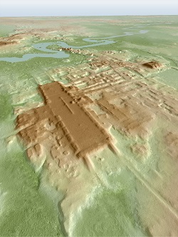
A 3D image of the site known as Aguada Fénix, with the aid of lidar technology. Courtesy of Takeshi Inomata.
Using data from both high-resolution and low-resolution lidar gathered in the last several years, researchers came across a find that would have been very difficult to identify from the ground. The site they identified is known as Aguada Fénix, which stood on a human-made plateau 1400 m long and more than 10 m high, abutted by a number of lower platforms. It contained 21 ceremonial structures in a rectangular configuration, with nine causeways.
“This is the western edge of the Maya area, and there was Olmec civilization farther to the west,” said Takeshi Inomata, a professor in anthropology at the University of Arizona. “We were interested in the relationship between the Olmec and the Maya, and for that study we thought this area is the key.”
Archaeologists estimate the community was constructed between 1000 B.C. and 800 B.C., based on radiocarbon dating of materials found on the site. At the end of that period, further building seems to have stopped.
A high-resolution lidar survey was conducted by the National Center for Airborne Laser Mapping (NCALM) in 2019, using a Teledyne Optech Titan Lidar system, with three channels of lasers at wavelengths of 1550, 1064, and 532 nm. The system was used from an airplane 650 m off the ground. The low-resolution lidar survey was performed for various purposes by the Instituta Nacional de Estadistica y Geografica (INEGI), a Mexican agency, using a Leica Geosystems ALS50-II lidar system in 2012.
“The high-res lidar shows archaeological features pretty well, but because of the high cost, we can get data for just select areas,” Inomata said. “Low-res lidar that INEGI did covered the entire state of Tabasco and its surroundings. It gives us the distribution of large sites in broader areas.”
Inomata noted that his research team used lidar to examine a broad expanse of the landscape in Guatemala in 2015.
“It has been revolutionary, particularly for the archaeology of the tropical regions like the Maya area,” he said. “The traditional ground survey was so time consuming, and we could never cover broad areas.”
He added that lidar was extremely beneficial in the case of Aguada Fénix, because it is so large that it easily blended into the surrounding environment. The airborne laser survey thus uncovered what researchers, and the general population, might have walked through for centuries without understanding its significance.
The research was published in Nature (www.doi.org/10.1038/s41586-020-2343-4).