ELENA BELETKAIA AND JOSE POZO, EUROPEAN PHOTONICS INDUSTRY CONSORTIUM (EPIC)
Night sky surveying requires that high-performance, low-light cameras be able to detect and measure the faint light signals coming from stars, comets, nebulae, and galaxies. The challenge at the camera level is that parameters must be extremely stable and operate with excellent performance over very long exposure times, sometimes even up to several hours.
Not only must the sensor have intrinsically high sensitivity, the camera itself needs to exhibit extremely low dark-current levels to sustain the required exposure times. It is essential that very few single electrons of dark current are generated, as their presence pollutes the incoming signal and makes detection of the events of interest difficult or impossible to achieve. Detection is achieved by extreme cooling of the sensor.
Night sky observation also demands the highest possible dynamic range and signal-to-noise ratios, with high reduction of other noise mechanisms. This requires that the sensor and camera electronics be perfectly integrated and matched. Next comes the resolution of the sensor: The sensor must have enough pixels to show even small astronomical objects clearly over several pixels in both directions.
Gas detectors for Earth, space
Besides observation of astronomical objects through detection of gases in space, a lot of other information about space as well as our own planet can be gained during night sky surveying.
An example is greenhouse gas detection. In 2016, 174 countries and the European Union signed the Paris Agreement and committed to reducing greenhouse gas emissions to keep global warming well below the critical point of 2 °C. Uncertainty and low-quality information about individual countries’ contributions make the overall picture of global emitters increasingly blurry. In response, the European Commission proposed a fleet of research satellites with test instruments and sensors to monitor CO2 emissions around the globe and hit climate and energy targets by 2030. The project is being planned by the European Space Agency.
IR sensors are one technique for accurately detecting gases. They use an IR beam to detect and measure gas concentrations. When a gas is present in the measurement chamber, a specific wavelength of IR light directed through the chamber is absorbed by the gas. The attenuated signal on the detector allows scientists to determine the gas and its concentration. For each gas of interest, a sensitive IR detector can be designed.
The IRnova AB portfolio includes detectors sensitive to methane, ethane, CO, Ketene, N2O, CO2, HFC, SF6, ethylene, and ammonia. Sensors for methane, for example, exploit type II superlattice (T2SL) technology; for SF6 gas, quantum-well infrared photodector (QWIP) technology is used. Sensors such as these are good examples of what can be used for greenhouse gas detection (Figure 1).
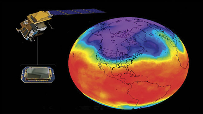
Figure 1. A concept of IR sensor-based monitoring of greenhouse gases. Courtesy of IRnova.
To explore other planets, mid-IR sensors are integrated in the equipment. The Tunable Laser Spectrometer (TLS) on board the Mars Science Laboratory Curiosity rover measures methane, water, and CO2 concentration in the Martian atmosphere.
Uncooled mercury cadmium telluride (MCT) IR detectors, developed at VIGO System SA, were chosen for use in a tunable laser spectrometer instrument designed to acquire information about the Martian environment during the Mars Science Laboratory mission. Moreover, a 2.78-μm laser from nanoplus Nanosystems and Technologies GmbH was used to detect CO2 and H2O isotopes in soil samples to determine whether Mars is, or has been, a suitable living environment. Both VIGO System and nanoplus are members of the MIRPHAB Pilot Line, a service for prototyping customized MIR miniaturized sensors (Figure 2) for companies interested in chemical sensing.
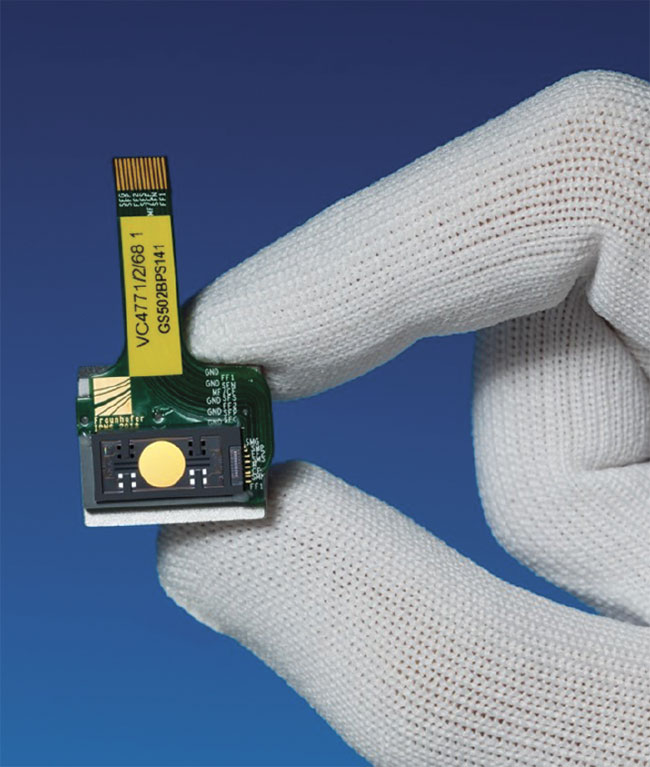
Figure 2. Micro-optoelectromechanical systems (MOEMS) integrated with grating couplers and lasers are components for the mid-IR systems offered by MIRPHAB. Courtesy of Fraunhofer IAF and Fraunhofer IPMS.
The ExoMars Trace Gas Orbiter (TGO) Martian mission showcases other accurate methods of gas detection. The orbiter is equipped with three gas detection systems (NOMAD, ACS, and CaSSIS). These systems aim to perform detailed, remote observations of the Martian atmosphere and search for a wide range of gases. NOMAD — Nadir and Occultation for Mars Discovery — is a spectrometer that can measure a wide range of wavelengths (IR, UV, and VIS), allowing detection of signatures for CO2, CO, H2O, NO2, N2O, O3, CH4, C2H2, C2H4, C2H6, H2CO, HCN, OCS, SO2, HCl, HO2, and H2S.
The detector used in NOMAD is the standard MARS-MW K508HSM integrated detector Dewar cooler assembly manufactured by Sofradir in France. This detector is a photovoltaic MCT detector with a focal plane array (FPA) of 320 columns × 256 rows and 30- × 30-μm-size pixels. The FPA is lodged in a vacuum Dewar with a customized 1-mm-thick silica front window (refractive index n = 3.4) with antireflective coating.
ACS, the Atmospheric Chemistry Suite, consists of three IR spectrometers: (1) a near-IR channel operating in the range of 0.7 to 1.7 μm with a resolving power of λ/Δλ ~ 20,000 and with a spectral range of 10 to 20 nm; (2) a mid-IR channel — an echelle spectrometer operating in the range of 2.2 to 4.4 μm; and (3) a far-IR channel — a Fourier spectrometer with an aperture of ~5 cm, which measures the spectrum of 1.7 to 17 μm.
CaSSIS, the Colour and Stereo Surface Imaging System, is a high-resolution camera (5 m/pixel) capable of obtaining color and stereo images. The back focal plane consists of a single silicon hybrid detector based on a Raytheon Osprey 2k hybrid CMOS detector. This detector can be read out extremely quickly with 14-bit digital resolution.
The combination of these systems with all of their high-performing detectors has already provided more detailed information about methane, water, and the surface of the red planet than did 16 years of data from its predecessor on board NASA’s Mars Odyssey.
Alternative space-imaging tech
An alternative technology for vision in space applications is imaging lidar. Lidar provides point cloud distribution representing the 3D environment, using the backscattering of a laser beam from the target surface. Lidar has long been used for mapping and atmospheric-sensing purposes, but now new uses are emerging thanks to solid-state, low-cost approaches that are delivering dense point clouds equivalent to an increased spatial resolution.
Lidar may be used alone in space robotics, or it may be combined with other sensors that provide complementary failure modes. This approach is being taken on the ground for autonomous vehicles, where different sensors complement each other for improved functionalities.
Imaging lidars typically need to take into account a number of different trade-offs regarding each specification. For example, the system shown in Figure 3a was designed and built for a desired space robotics application where real-time, very dense point clouds — 350 × 350 ppf at 3 fps — were required, including the information of position (XYZ) and the reflectance of the target at each point (Figure 3b).
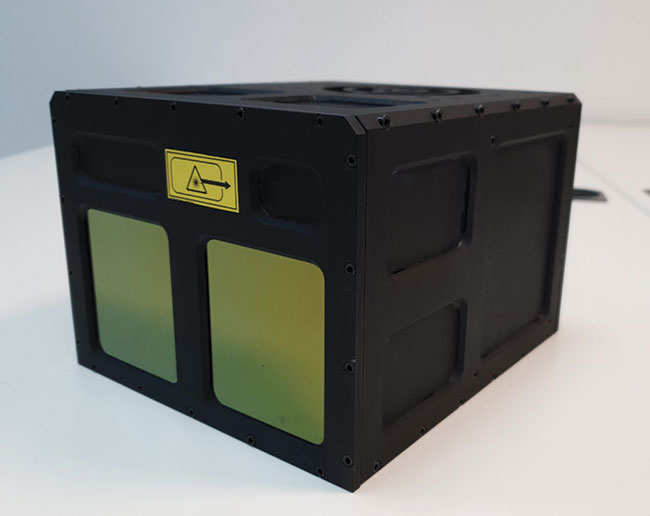
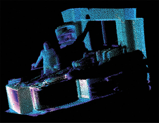
Figure 3. Imaging lidar for space applications developed at Beamagine SL (top). Point cloud in reflectance mode, showing a high-density cloud
where each point contains XYZ and reflectance information (bottom). Courtesy of Beamagine.
Lidars for space application, as well as low-light cameras and sensors for gas sensing and environmental monitoring, will be discussed in detail during the upcoming EPIC Meeting on New Space at the European Space Agency, Sept. 12-13 in Noordwijk, Netherlands. During this meeting, other topics — such as optical networks, atomic clocks, atom interferometry, and quantum technologies application in space — will also be covered.
Meet the authors
Elena Beletkaia, Ph.D., is project leader at the European Photonics Industry Consortium (EPIC). She graduated from Lomonosov Moscow State University, where she specialized in biophysics. In 2015, Beletkaia received a doctorate from Leiden University, where her research focused on biochemical and biophysical mechanisms underlying metastasis of Ewing sarcoma. Later, in the collaborative setting of NKI (Netherlands Cancer Institute) and the University of Twente, she investigated the application of noninvasive spectroscopic/multiphoton methods for intraoperative resection margins assessment. All of Beletkaia’s research projects have involved the understanding and use of multiple microscopic and spectroscopic techniques.
Jose Pozo, Ph.D., is the director of technology and innovation at the European Photonics Industry Consortium (EPIC), with close to two decades of experience with photonics technology. He has a doctorate in electrical engineering from the University of Bristol in England, and bachelor’s and master’s degrees in telecom engineering. Pozo is a member of the board of the IEEE Photonics Society Benelux.