The advent of miniaturized satellites and privately led space initiatives has ushered in a revolution in space-based imaging of Earth and beyond.
VALERIE C. COFFEY, SCIENCE WRITER
Half a century ago, the first Space Age was in full swing, funded by large government budgets and fueled by economic-political pressure to dominate space exploration. Today this movement has evolved into NewSpace — a revolution in the space industry in which private and nongovernment-backed entities worldwide are helping to develop faster, better, cheaper commercial space initiatives. In the last five to 10 years, thousands of NewSpace companies have poured billions of dollars into building new launchpads and launching hundreds of smaller, lighter satellites and space-based observation platforms into orbit, enabled by the miniaturization of inexpensive computers and optoelectronics.
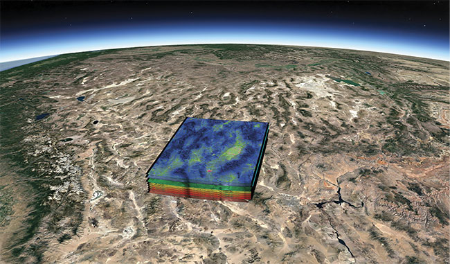
Earth-observing hyperspectral satellites obtain images along with highly precise spectral information in hundreds of nearly contiguous bands. Correlating the spectrum with a pixel in the image enables location of molecular and chemical signatures in the environment, such as
methane emission from industrial facilities. Courtesy of Cosine Measurement Systems.
NewSpace reflects a major shift in the space industry. Technology that originated from the space race of the 1960s, such as memory foam and Mylar space blankets, eventually transferred into consumer applications. NewSpace entities such as SpaceX, founded by Tesla’s Elon Musk; Blue Origin, founded by Amazon’s Jeff Bezos; and Virgin Galactic, founded by Richard Branson are forging innovative commercial launch technologies and space-based services that significantly bring down the cost of access to space for paying customers, including governments. Instead of NASA developing the technology and transferring it to consumers, NewSpace companies are developing technology that may be transferred to NASA. At the same time, along with the commercial leverage that new satellites will provide, many NewSpace companies are asserting more benevolent socioeconomic motivations to achieve a space program they hope will benefit all of mankind. In addition to satellites, many space agencies and NewSpace companies now cite human colonization of space as their main mission.
The satellites above Earth are mainly designed for two purposes: communications and Earth observation. The need to observe, analyze, and understand all kinds of change drives the demand for daily high-resolution imaging of our planet. Hoisting advanced cameras and sensors into low Earth orbit (LEO) enables consumers to receive cable television and satellite radio broadcasting, satellite communications, and GPS positioning. In addition, the ability to image land masses and coastal regions enables scientists to monitor natural disasters, deforestation, water quality, ozone depletion, pollution, crop quality, and climate change. Following in the steps of builders of smaller CubeSats that currently ring Earth, satellite designers can now install miniature optoelectronics originally developed for cellphones into tiny, robust multispectral and hyperspectral (HS) imaging systems that are the size of a loaf of bread but have greater imaging capabilities than the bus-size platforms of a generation ago (Figure 1). Leveraging consumer electronics to shrink bus-size satellites down to 10 × 10 in. greatly decreases the cost over previous satellites.
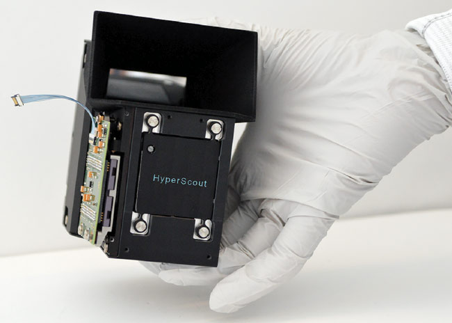
Figure 1. The HyperScout hyperspectral imager, now in orbit aboard the GomX-4B CubeSat, gathers environmental data in 45 different spectral bands and performs its own onboard processing to reduce the amount of data sent back to the ground. Courtesy of Cosine Measurement Systems.
“What you can stuff inside the payload fairing of a rocket has changed dramatically — not by 2× but by 200×, even 2000×,” said Will Marshall, co-founder of San Francisco-based Earth-imaging company Planet Labs Inc., at the Bloomberg Sooner Than You Think Summit in June. “We’re jumping now to [costs that are] 200 to 300× cheaper than previous satellites.”
A race for improvement
Reducing the size, weight, and cost of such imaging satellites has spawned many promising new initiatives. Among them is multispectral and HS imaging as a service to industry and government. HS sensors generate images containing highly precise spectral information in hundreds of bands that enable identification of molecular and chemical signatures in the environment, such as in water, soil, and crops. In comparison, multispectral sensors sample spectra in several bands, offering less flexibility in their target signature than HS, but they have higher spatial resolution to see smaller details on the ground, such as detecting which tree in a stand has pests. Multispectral imaging has a long history: Landsat 7, which has been in orbit since 1999, has eight spectral bands, and Landsat 8, launched in 2013, has 11 bands. These satellites can discern ground details measuring between 15 and 100 m, depending on the band. Over a dozen entities have launched or have plans to develop their own constellation of satellites in the next decade, which will be able to obtain HS images in high spectral resolution.
Part of the challenge for developers and users of HS imaging is bridging the gap between spectral and spatial resolution. Designers can optimize one but not both due to limitations in data processing time and cost. An imager can obtain greater coverage swaths and more spectral bands, but doing so would explode data volume and the time to download and process it. Designers must also consider cost, whether a design is feasible, and the radiometric resolution — the minimum signal-to-noise ratio required to detect the signal on the ground. The companies planning to launch commercial HS imaging satellites are taking a variety of approaches to address these trade-offs. The space-based imagers will be available for governments and businesses to hire — to target and observe custom areas of interest at high spectral resolution for numerous applications, including meteorology, agriculture, oceanography, forestry, cartography, intelligence, and many others.
The first snapshots of Earth from space were taken aboard suborbital planes in 1946. Today, the majority of satellites accomplish imaging via a “push-broom” technique in which the satellite scans Earth from a polar orbit every 90 minutes or so. To image all of Earth’s surface every day takes multiple satellites in the same orbit, looking somewhat like a string of pearls. As one satellite sweeps along a longitudinal image area, Earth rotates underneath, so the next satellite acquires an adjacent longitudinal line (Figure 2).
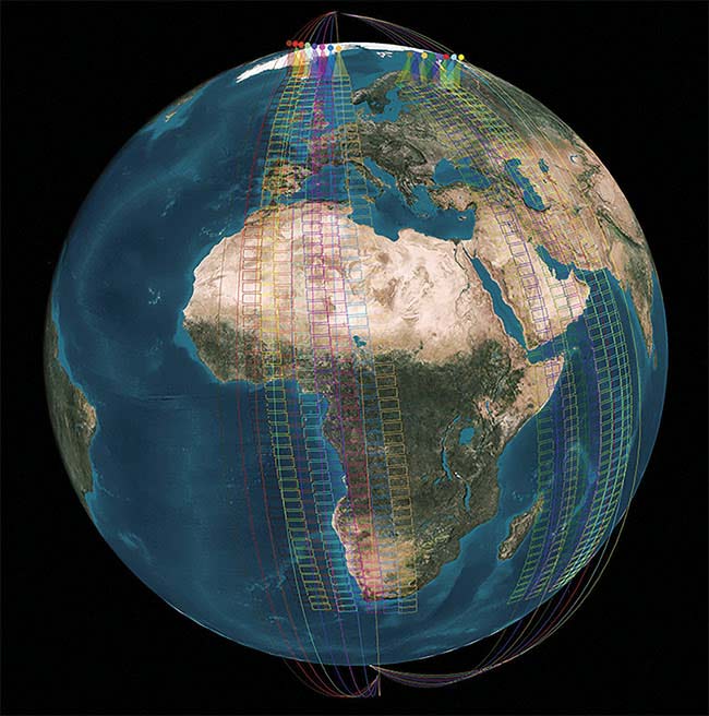
Figure 2. A constellation of satellites in a polar Earth orbit performs repeated “push-broom” line scanning of its surface. The HyperScout 1 miniature HS imager was the first to process images in orbit from the GomX-4B to save data downlink time. The first test of its onboard processor took approximately one minute to process data that would have taken several weeks to download from a nanosatellite. Courtesy of Cosine Measurement Systems.
Emerging HS solutions
In February 2018, Dutch technology company Cosine Measurement Systems (Warmond, Netherlands) launched its HyperScout HS imaging compact telescope aboard the European Space Agency’s (ESA’s) GomX-4B CubeSat nanosatellite. Orbiting at 300 km, the HyperScout can record 45 spectral bands in the visible and very near-infrared (VNIR) range from 400 to 1000 nm, with a spatial resolution of 40 m per pixel ground sampling distance (GSD), 50 spectral bands at a spectral resolution of 12 nm full width half maximum (FWHM) in extended range mode, or up to 150 spectral bands from 470 to 900 nm at 5 nm FWHM. This was the first launch of the HyperScout into space, and the first real test of its capabilities. In 2020, HyperScout 2 will be launched as part of the ESA Phisat on the FSSCat mission. HyperScout 2 is expanded, with four thermal infrared spectral bands and artificial intelligence processing on board to enable applications such as the monitoring of vegetation changes and water quality.
Acquiring hyperspectral data is useful to scientists, but getting all the data to Earth quickly and efficiently is a challenge. Typical downlink data rates from CubeSats are only 1 Mb/s due to limited space and power aboard the platform. Thus, onboard processing is an up-and-coming design solution. The HyperScout incorporates onboard near-real-time data processing, enabling significant reduction in the time to download and process data. The Belgian remote sensing institute VITO BV developed algorithms implanted in the imager that correct for observation angle and the curvature of Earth. In concert with Delft University of Technology in the Netherlands, space science company Science & Technology Corp. in Oslo, Norway, developed software uploaded to the satellite after launch that enabled the device to run the ground-based VITO algorithm. Cosine offers HyperScouts built to order with a three-month lead time and custom HS imaging for applications such as monitoring of natural disasters, drought, soil saturation, and land surveying.
Many other hyperspectral satellite initiatives are in the works. Here’s a sampling of recent news:
• Planet Labs launched 33 CubeSats into orbit from the International Space Station (ISS) in 2014 and has since launched hundreds more. Since 2017, the company has been able to image the entire landmass of Earth and the surrounding coastal areas every day. As of October 2019, the company holds the record for the largest number of private satellites in orbit in history: 200. That’s more than Russia, which has 147, according to the World Economic Forum.
• Argentinian startup Satellogic has eight satellites in orbit that combine multispectral and hyperspectral imagery; 16 more satellites are scheduled to launch in late 2019 and mid-2020.
• In November 2018, the Indian Space Research Organisation (ISRO) launched the HS Earth-imaging satellite HySIS into a 636-km-high polar sun-synchronous orbit (SSO), with imaging capabilities in the VIS-NIR and shortwave IR (SWIR) bands (Figure 3).
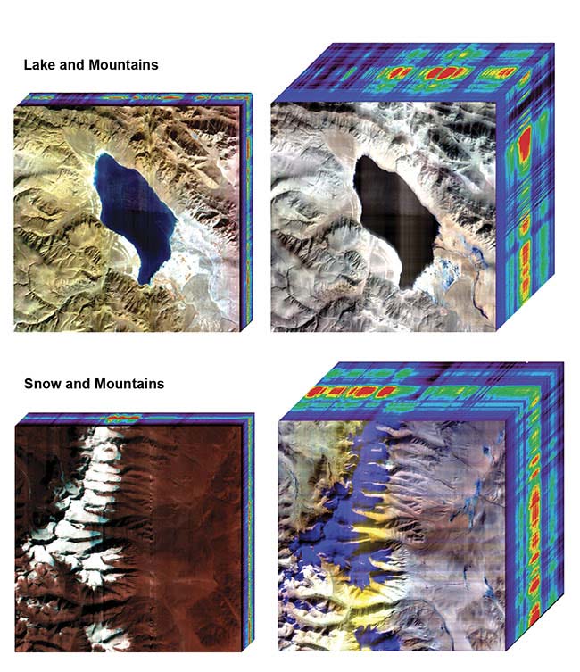
Figure 3. The HySIS Earth observation satellite launched in November 2018, providing
imaging services for India, with 60 contiguous bands in the visible to NIR from 400 to 950 nm (left), and 256 contiguous SWIR bands ranging from 850 nm to 2.4 µm for defense,
agriculture, forestry, and coastal geography monitoring. Courtesy of the Indian Space
Research Organisation.
• In March, the Italian Space Agency ASI launched the hyperspectral Earth observation satellite PRISMA (an Italian acronym for Hyperspectral Precursor of the Application Mission) into an SSO, keeping the satellite in place above the daytime side of Earth (Figure 4).
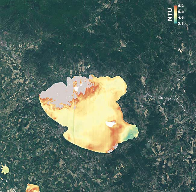
Figure 4. In less than two seconds, the PRISMA hyperspectral imager satellite obtained turbidity measurements of Lake Trasimeno in Perugia, Umbria, Italy, the fourth largest lake in Italy with 128 sq km of surface area. The water was found clear and free of algae. NTU: nephelometric turbidity unit. Courtesy of Italian Space Agency ASI.
• The German-made EnMAP hyperspectral telescope imager with 240 adjacent spectral bands from 420 to 2450 nm (visible to SWIR) and a spatial resolution of 30 m is currently being developed for launch and commissioning on the ISS in 2020.
• According to satellite missions expert Keith Beckett at NewSpace technology company MDA in Richmond, British Columbia, Canada, an Earth-observation satellite that can attain and maintain radiometric and spectral calibration is currently needed, since the Hyperion sensor on the Earth Observing-1 satellite was decommissioned in 2017 due to age and degradation. “The loss of the Hyperion sensor created difficulties for calibrating hyperspectral data from other platforms,” Beckett said. “The HySIS data will be in high demand once it’s fully operational and its calibration well validated, because it is in an SSO orbit used by most Earth-observation satellites.”
The future in space
Many space agencies are focused on the mission of human habitation and colonization of space, including the development of exploration bases on the moon and Mars, but decades of further research and development are needed before that will happen. Future challenges for those launching equipment into space include managing the sheer mass of intersecting satellite paths and preventing collisions. Any collision between two satellites in orbit would cause degradation of their path and eventually their destruction as they burn up in the atmosphere — even if people are safe down on the ground. Still, to protect the investment, developers believe future satellites should have residual fuel and the ability to execute collision avoidance and orbit correction. Companies will also face challenges involving ethics concerns. For example, how do they strictly manage data that can reveal national security secrets? Companies will need to carefully screen paying customers to prevent the use of all these detailed images for nefarious purposes, such as terrorism or theft.