
Rain Forest Greenery Reveals Chemical Mosaic
To help scientists investigate and monitor the health of the world’s rain forests, the Carnegie Airborne Observatory (CAO) represents a high-tech and vital resource. Global ecologist Greg Asner and his team from the Carnegie Institution for Science, based in Washington, D.C., recently used the aircraft laboratory to create high-resolution maps of the complex chemical variation of the rain forest canopy across the lowland Amazon. They found that plants in different areas produce a set of chemicals that changes across the region’s topography. Their work is published in Nature Geoscience (doi: 10.1038/ngeo2443).
“We carry the most advanced imaging spectrometer operating in the world today.
It can measure the radiance [reflected light] of the Earth’s surface in 480 spectral channels and, critically, it can do so with very high uniformity and signal-to-noise performance,” Asner said. He completed building the first CAO in 2006, after years of beta-testing with other organizations, including NASA. The third-generation CAO-3 laboratory was launched in 2015.
The team’s work has been providing information on how the rain forest ecosystem functions on a large scale.
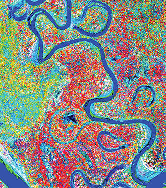
Airborne laser-guided imaging spectroscopy has enabled scientists to observe that lowland Amazon forests are grouped together in chemical communities based on the soils and the geographical features on which they grow. This Carnegie Airborne Observatory (CAO) image shows floodplain forest canopies in red that are abundant with growth chemicals, as compared to forest canopies on bordering terraces in yellow-green that display fewer growth chemicals. According to Carnegie researchers, the maps explain the geographic pattern of carbon dioxide uptake in the lowland Amazon and help to predict forest responses to climate change. Courtesy of Greg Asner.
Each of the rain forest’s many trees and plant species develops a set of chemicals needed to help it carry out its life functions, including harvesting sunlight, fending off herbivores, attracting pollinators and adapting to climate change. Variation in topography affects every plant’s water, nutrients and other resources.
Using airborne, laser-guided image spectroscopy, Asner and his team mapped the chemical fingerprint of four large forests along the Madre de Dios and Tambopata rivers in South America’s western Amazon basin. The maps are based on quantitative chemometric analyses of forest canopies with visible to near-infrared (400 to 2500 nm) spectroscopy. The team’s results show that the pattern of chemical properties of canopy trees changes along the paths of the two rivers, as well as across the landscape’s topography. The team observed that even small changes in elevation make a difference to the plants.
“Looking at the lowland Amazon with this kind of detail, you can see back in time, from the way the topography was shaped millions of years ago, which still affects soils and mineral availability today, to the way that different species evolved to take advantage of this great variety of subtly changing conditions,” Asner explained. “And we can peer into the future and see how quickly human activity is changing the kaleidoscope of diversity that has been uniquely shaped over millions of years.”
According to Asner, Peru’s portion of the Amazon is the most biodiverse part of the entire basin — it has more species per acre than any other part of the entire region. “At the same time, very little is known about the Peruvian Amazon, so we are working to reveal what is contained in the forest,” he added.
When on the ground, Asner runs the largest field plot network in Peru, designed to calibrate and interpret the team’s aircraft-based measurements. Asner has been working in the Amazon region since 1995 and in the Peruvian part of the Amazon since 2006.
“Flying and operating in really remote areas with limited jet fuel, harsh conditions and lots of cloud cover to avoid” are among the more challenging aspects of studying the rain forest, said Asner. While it took him about 10 hours to fly over the area along the two rivers, he has now mapped all of Peru — an area three times the size of California. It took him about six months. “I will reveal those results in the coming year. They are mind-blowing.”
Published: September 2015