
SWIR System Images Forest Fire from Orbit
A satellite-mounted shortwave infrared (SWIR) system built by Exelis Geospatial Systems has been used to image a forest fire through a thick cloud of smoke.
The system includes a SWIR imager, sensors and telescope and operates aboard the DigitalGlobe WorldView-3 satellite, which was launched in August and is now in orbit 617 km above Earth. It is the first system of its kind on a high-resolution commercial satellite.
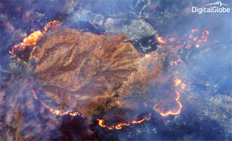
A false-color composite made from three of the eight SWIR bands (6, 3 and 1) that coincidentally give an orange color to the fire. Courtesy of Excelis.
Taken above the Happy Camp complex in California’s Klamath National Forest, the images show an active fire beneath a thick cloud of smoke. Hot spots are clearly visible even without being shown at full resolution.
“These images show how SWIR technology can directly benefit firefighters and help save lives,” said Rob Mitrevski, vice president and general manager of Exelis Geospatial Systems. “SWIR can remove some of the guesswork in determining where hot spots are to help firefighters plan their approach.”
For more information, visit www.digitalglobeblog.com.
Published: September 2014