DENVER, Nov. 4 -- Commercial satellite imagery is being used before and after wildland and forest fires as an advanced forestry and fire management decision-support tool for planning and remediation.
Denver-based Space Imaging's Ikonos satellite took this one-meter image of the Devore Heights area of San Bernardino County, Calif., one of California's "hot spots," on Oct. 28. The image shows flames and smoke near the intersection of I-15 and I-215. Devore Heights is just north of the Lytle Creek area and is 12 miles west of Lake Arrowhead.
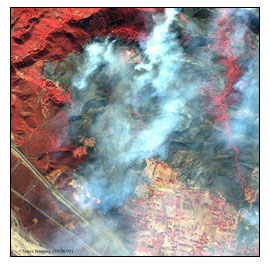
BIG PICTURE: High-resolution satellite images of the California wildfires show wide area destruction along I-15 in San Bernardino, Calif. The images were taken by Space Imaging's Ikonos satellite on Oct. 28 while orbiting 423 miles above Earth. (Photo: Space Imaging)
In this false-color image, taken in the near-infrared light spectrum, the bright red areas indicate green or living vegetation. The blackened areas in the middle depict burned areas, and large flames can be see along the north side of I-15, at the bottom of the image.
Firefighters contained the largest and deadliest of Southern California's vast wildfires today and made progress against others, the Associated Press reported. The recent fires have swept across more than 743,000 acres, claiming at least 20 lives and destroying more than 3,570 homes, according to news reports.
Space Imaging said satellite imagery can pinpoint where forests need to be thinned and can identify individual trees that may have been killed by disease or insects.
The company recently completed a fire risk assessment project for the Florida Division of Forestry that identifies the potential seriousness of fires in that state and prioritizes areas where mitigation options may be desirable. In July, Space Imaging's Wildland Fire Risk Assessment System was selected by the Southern Group of State Foresters to support ongoing fire management planning and wildland fire risk analysis in Alabama, Arkansas, Mississippi, Florida, Georgia, Kentucky, Louisiana, Virginia, Texas, Tennessee, South Carolina, North Carolina and Oklahoma.
For more information, visit: www.spaceimaging.com