It can be used underground, underwater and even in space. A versatile new system, it comprises innovative optics that can be used with any spectrometer, can collect more than 1000 colors and is so stable and reliable that it can be used to detect contaminants and other environmental hazards almost anywhere and in real time.
The fore optics (the optics in front of the sensor) were developed by researchers at Tel Aviv University in Israel. The result is a small, easy-to-use system that can remotely monitor harmful contaminants in forests, urban areas, agricultural lands, harbors and marinas.
Although initial applications focused on monitoring and protecting the environment, professor Eyal Ben-Dor at Tel Aviv University’s Department of Geography and the Human Environment noted that the system has both commercial and scientific applications. For example, it can be used to help companies adhere to regulations on environmental contamination.
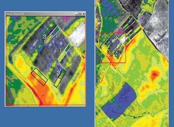
This map shows the infiltration rate of water within a soil profile generated using the AISA hyperspectral sensor (developed at Specim in Oulu, Finland) mounted onboard an aircraft. Such maps help farmers manage water consumption and prevent soil erosion. Areas 1, 3 and 4 indicate validation areas where the infiltration rate was measured. Area 4 represents a low infiltration rate and, hence, high potential for runoff. In each area, two subfields exist with low (warm color) and high (cold color) infiltration rates.
When the device is used in combination with a hyperspectral camera, spatial domain is added to the system’s spectral capability. The camera can read information from as close as 1 cm to as far as 800 km, meaning that it can be placed anywhere from the ground itself to unmanned aircraft, satellites or weather balloons. It also can be pointed toward the stars to help astronomers gain insight into the makeup of a planet’s atmosphere.
The prototype of the device is described in an article published in Soil Science Society of America (2008, Volume 72, Issue 4, pp. 1113-1123; doi:10.2136/sssaj2006.0059), where its first use was to assess underground soil horizons down to 100 cm. In this case, the device was assembled in combination with a spectrometer to extract the spectral fingerprint of the soil profile with quantitative information.
The assembly, dubbed the SpectralTool, works by interpreting reflected light from the sun (or another source) as it bounces off an object, material or environment. It is connected to a spectrometer, where the incident light is dispersed into several spectral channels using a prism and is directed toward a detector composed of an array of microsensors.
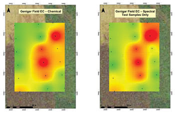
Microscale salinity maps of agricultural fields – such as these maps of a plot in Genigar Field in Yizre’el Valley in Israel – help farmers manage their optimal yield production. The left image was generated by conventional field work. The right image was generated from ground measurements acquired by the new SpectralTool assembly and is 100 times faster to produce. EC = electrical conductivity. Images courtesy of Eyal Ben-Dor, Tel Aviv University.
Each microsensor generates one pixel and represents a different chemical reaction between two compounds. The original device operates from 0.4 to 2.5 µm – to encompass the sun’s radiation – depending upon the spectrometer’s capability. The latest system also can work from 3 to 15 µm – to use the radiation from the Earth – based on the new field spectrometer sensitive to that range and commercially available.
 The point information can be projected onto the spatial domain by using an imaging camera. “The resulting image is now composed of spatial dimension (the pixel’s column arrangement) and spectral dimension (the pixel’s row dimension),” Ben-Dor said. “The end product is a spectral ‘cube’ that represents radiation fluxes that then translate into reflectance values in order to compare with spectral libraries measured by our instrument.”
The remote capability of the hyperspectral device enables real-time analysis of environmental composition – samples of soil, sediment or water – without so much as a touch.
The scientists say that the potential uses of the spectral information are endless. Their device and other similar versions available can benefit areas including medicine, pharmacology, the textile industry and civil engineering. It can be used, for example, to survey the areas around gas pipelines for leaks, to determine salt levels in soil to save crops before they are destroyed or to monitor water quality in marinas, which often are highly contaminated by gasoline and sealants from the undersides of sea vessels.
“There are some applications still not known – or developed – suggesting that it is just an emerging and promising field,” Ben-Dor said.