Fifteen meters below the northern French city of Arras, researchers have been busy laser scanning a network of caves and tunnels to document and preserve New Zealand’s presence during World War I.
More than 120,000 New Zealanders enlisted during the First World War, serving in battles such as Gallipoli, Messines, Passchendaele and Le Quesnoy. Of that group, 1308 men — the New Zealand Engineers Tunnelling Company — were given a highly secret mission to locate and connect abandoned underground chalk quarries that would allow allied soldiers to pass safely beneath Arras on their way to the frontline trenches for battle. The underground tunnel system could accommodate up to 24,000 soldiers, though it is believed that many more passed through the complex leading up to the Battle of Arras in 1917.
Today, the chalk quarries, known as the Ronville network of tunnels, are deteriorating and the city above ground is developing, meaning the tunnels won’t last forever. The LiDARRAS project — made up of students and researchers from the University of Otago’s National School of Surveying in Dunedin, New Zealand, and École Supérieure des Géomètres et Topographes (ESGT) in LeMans, France — is using stationary lidar to digitally preserve the 2.3-km-long underground city that included a light rail system, running water, electric lights and a hospital.
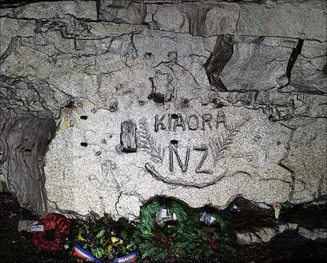
‘Kia Ora’ (‘Hello’ in Ma¯ori) surrounded by New Zealand silver ferns engraved in the chalk in the Blenheim quarry by the men of the New Zealand Engineers Tunnelling Company and captured by the LiDARRAS survey. Courtesy of Pascal Sirguey.
The team — led by Pascal Sirguey, senior lecturer at the University of Otago’s School of Surveying — completed approximately 1000 terrestrial laser scans using a Trimble TX8 laser scanner (capable of collecting a million points per second), a NikonD5100 16MP digital SLR camera with a Sigma 8-mm fisheye lens and a total station that uses laser technology to measure distances precisely. They also used a Trimble TX5 for a small number of subsurface tunnels and surface exit tunnels. In total, the project surveyed nearly 100 billion points with millimeter accuracy and produced a photo-realistic 3D model of this significant heritage with unprecedented resolution.
“From the individual laser scan measurements, we are able to stitch or register together all of the scans into a complete point cloud model of the underground complex as well as areas of the street-scape above them,” said Richard Hemi, a professional practice fellow at the University of Otago’s School of Surveying. “Using more conventional survey traversing, we are also able to maintain the spatial accuracy throughout the model by georeferencing, or forcing accurate point coordinates into an array spaced evenly around the site.”
Hemi told Photonics Media that the LiDARRAS project has uncovered tunnel walls covered in New Zealanders’ names, sketches and other graffiti etched into the rock by soldiers in the lead-up to the battle.
“The use of photonics — in this case, the use of 3D laser scanning — is important in that it has given us the ability to capture these historic tunnels and quarries so as to document them for the future and make them digitally accessible to a wider and distant audience,” he said. “There has been a great deal of satisfaction to have completed the actual survey work — the lengthy scanning, the precise survey control and generally working and getting by in a somewhat difficult working environment 15 meters below ground.”
The next plan is to turn all of the data from the underground city into a 3D virtual tour of the labyrinth. Visitors will be able to navigate the underground tunnels in all directions much like a video game, while the physical cultural heritage site of New Zealand’s presence during WWI is preserved.