Firefighters and photonics engineers are leveraging a full spectrum of imaging and other optical technologies to minimize the impact of wildfires before, during, and after the burn.
JAMES SCHLETT, CONTRIBUTING EDITOR
In October 2016, a downed powerline sparked a wildfire that raged for two weeks and destroyed more than 18,000 acres in the Pike and San Isabel National Forests west of Pueblo, Colo. The so-called Junkins fire ended up destroying nine homes and 17 other structures, and the carnage could have been worse had it not been for photonics.
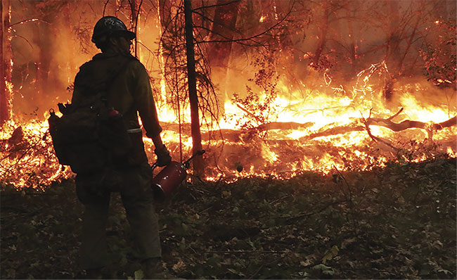
A firefighter at the 2018 Delta fire near Lakehead, Calif., in the Shasta-Trinity National Forest. Courtesy of U.S. Forest Service.
As the blaze rapidly approached structures, an interagency incident management team coordinated with aviation and ground resources to conduct burn operations to halt the fire’s progress. Midway through the operation, a Colorado Multi-Mission Aircraft, using an IR camera, detected spots down a deep slope that contained a vast amount of combustible material, a condition referred to as “heavy fuel loading.” The aircraft crew alerted firefighters and the spots were quickly extinguished.
“The quick and early detection combined with rapid response to a specific location prevented any further spread of the fire and allowed the burn operations
to continue, eventually leading to the containment of the fire,” said Babete Anderson, a U.S. Forest Service (USFS) spokesperson.
The role photonics played in controlling the Junkins blaze is just one example of the technology’s growing contributions
to preventing, fighting, and recovering from wildfires. With wildfires setting a record in 2020 for the number of acres burned, the disasters are fueling greater demand for photonics-generated data. Last year, 58,300 U.S. wildfires burned 10.3 million acres, with roughly 40% of that acreage located in California, according to data from the National Interagency Fire Center.
Sparking innovation
“The prevalence of wildfires is definitively a strong motivation for pushing the boundaries of scientific research,” said Jean-Philippe Gagnon, a field applications scientist with the Quebec camera maker Telops. The company has been working with several researchers to develop a method to estimate the absolute temperature of a material without prior knowledge
of material emissivity. The n-color temperature-emissivity separation method uses data acquired with a multispectral
IR camera.
Analyzing the composition of wildfire smoke has been another driving force for innovation in photonics. When smoke from wildfires clouded the northern British Columbia hometown of an executive for the Vancouver-based company Nanozen, he became frustrated with the inability to measure the air quality in real time using current regulatory-approved methods. “He decided to design and modify our current [optical particle counter] sensor to be able to detect wildfire particulate accurately,” said Winnie Chu, Nanozen’s CTO.
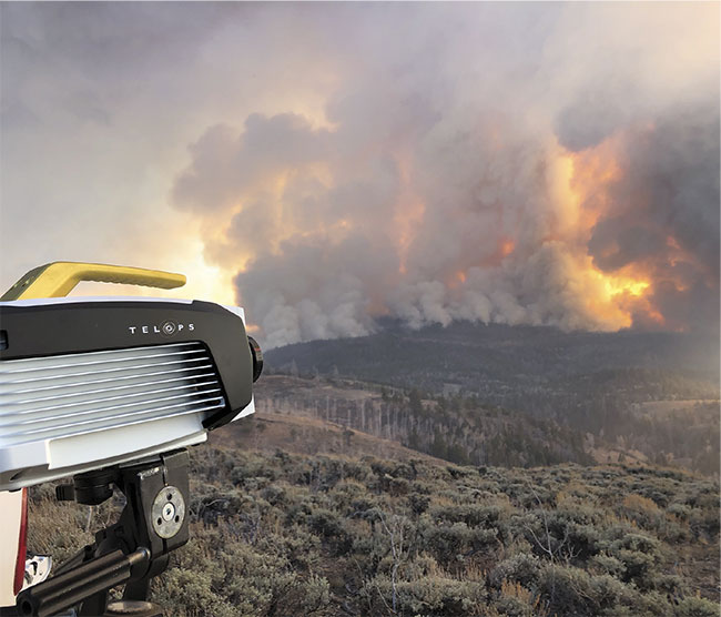
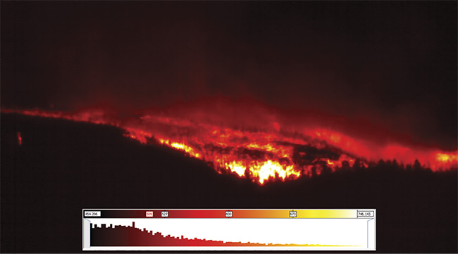
A Telops M150 camera is aimed at a U.S. Forest Service-prescribed fire in Utah in October 2019 (top). An IR image of the same burn (bottom). Courtesy of Craig Clements.
The U.S. Environmental Protection Agency and the U.S. Department of Agriculture have also taken an interest in real-time measurements of wildfire air quality, particularly for firefighters. In 2019, the agencies each awarded California-based KWJ Engineering with $100,000 grants to develop a wearable device that would integrate screen-printed gas sensors and optical particle sensors.
To study smoke at night, the National Oceanic and Atmospheric Administration (NOAA) developed two photonic-intensive payloads for in situ fire plume sampling of aerosols, carbon oxide (CO), and carbon dioxide (CO2), as well as for remote sensing of fire temperature. Lightweight enough to be mounted on an unmanned aerial system (UAS), the payloads will enable combustion efficiency estimations and the mapping of active fire areas, smoldering, and hot spots.
With smoke posing navigational risks that are compounded during night flights, NOAA tapped UAS solutions provider Black Swift Technologies for Nighttime Fire Observations eXperiment (NightFOX) missions. NOAA plans to deploy UAS-mounted sensors to collect wildfire measurements this summer and fall. Logistical issues and COVID-19 postponed night missions in 2019 and 2020, according to Troy Thornberry and Ru-Shan Gao of NOAA’s Chemical Sciences Laboratory.
NightFOX’s in situ payload includes a nondispersive IR absorption sensor, a portable optical particle spectrometer, and an optical particle counter. The remote sensing payload uses FLIR cameras for visible and thermal imaging, as well as imagers capturing in the near-infrared (NIR) and midwave infrared (MWIR) bands.
“Although satellites provide coverage on a much larger scale, they’re rarely on demand, and when making measurements like plume density and composition, [they] have to look through a column rather than make a more accurate point measurement, something a UAS specializes in,” said Jack Elston, Black Swift’s CEO. “I see the two technologies as highly complementary, with satellites providing an overview, as well as information that can be passed on to the UAS teams to perform higher-resolution or targeted in situ observations.”
Burning demand
The USFS’s Anderson said, “Hyperspectral, multispectral, and lidar data is collected to assess the conditions of the fuels for wildfire planning and fuels assessments.” This data assists fire staff members in the decision-support process as they assess the potential of fuel buildup. Prevention officers can also see where to increase prevention activities.
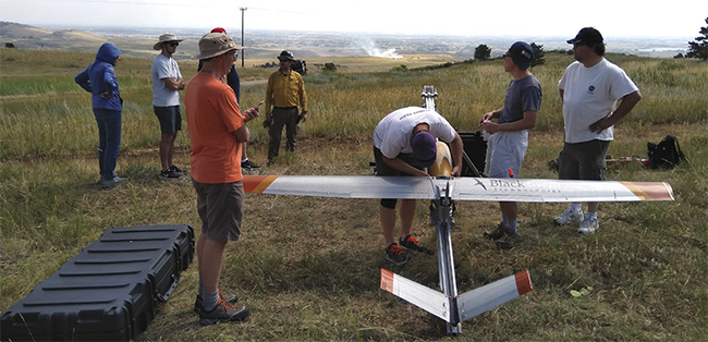
Black Swift Technologies’ SuperSwift unmanned aircraft system is prepared for flight with its sensor payload. A prescribed burn appears in the distance. Courtesy of Black Swift Technologies.
NASA’s Jet Propulsion Laboratory (JPL) has developed an array of Earth-observing instruments on aircraft and
satellites that are guiding wildfire management efforts worldwide. JPL’s Airborne Visible/Infrared Imaging Spectrometer (AVIRIS-Classic) has been providing airborne hyperspectral imaging since 1986. The system estimates the components and conditions of vegetation fuel types and was succeeded by the next-generation AVIRIS-NG.
According to Kerry Cawse-Nicholson, a co-lead for JPL’s Surface Biology and Geology (SBG) mission study Algorithms Working Group, photonics technology is contributing to other wildfire management instruments as well, including:
- The Advanced Spaceborne Thermal Emission and Reflection Radiometer (ASTER), which makes multispectral measurements in the LWIR, SWIR, and visible ranges to detect fires.
- The Multi-angle Imaging SpectroRadiometer (MISR), which provides angular measurements that characterize smoke plumes.
- The Atmospheric Infrared Sounder (AIRS), which monitors carbon
monoxide emissions from fires.
- The Hyperspectral Thermal Emission
Spectrometer (HyTES), which provides estimates of plant stress, land surface temperature, and aerosol emissions.
- The Moderate Resolution Imaging Spectroradiometer (MODIS), which monitors plumes of methane, hydrogen sulfide, ammonia, nitrogen
dioxide, and sulfur dioxide. HyTES has been used for similar applications.
Hyperspectral data deficit
Last November, JPL partnered with three California agencies to allow them access to data from Earth-observing satellites and other ground-based technologies. Lisa Lien-Mager, a spokeswoman for the California Natural Resources Agency — one of the agencies partnering with JPL — said, “There is an information gap, particularly in the first 24 hours after a fire starts. More timely and accurate information is needed during the period between ignition detection, identification of evacuations, and deployment of firefighting resources.”
Out of the three phases of the wildfire continuum — pre-fire, active fire, and post-fire — the middle stage is where remote hyperspectral imaging is utilized the least. But this is not because hyperspectral data isn’t valuable to fighting wildfires, said Sander Veraverbeke, an assistant professor in remote sensing at Vrije Universiteit Amsterdam. Hyperspectral imaging can outperform multispectral imaging, Veraverbeke said, because its narrow bands capture narrow gaseous absorption spectra that are averaged out by broad bands. Yet multispectral imaging dominates the remote sensing of wildfires because of the level of maturity the technology has achieved from sensors such as JPL’s MODIS and Landsat.
“After decades of experience with spaceborne multispectral remote sensing, these multispectral algorithms and data-sets are well in place and readily available for emergency management,” Veraverbeke said. “Spaceborne hyperspectral remote sensing is at best at the scientific exploration stage, and there is still a long way to go till these datasets will reach emergency management.”
The launch of several hyperspectral satellites by international space agencies promises to help bridge the data deficit that has limited the use of this photonics technology in the active fire stage. The past three years have seen the launch of the Italy’s PRISMA and Japan’s HISUI hyperspectral satellites. However, JPL’s Dave Schimel, a science and applications lead for the SBG mission study, said these new instruments cover a narrow swath and provide very limited coverage. They are case studies more than global surveillances, he said.
“Lack of data is the largest limitation for spaceborne hyperspectral imaging,” Veraverbeke said. “This is especially true with fires, which are an ephemeral and somewhat unexpected process that is hard to plan in airborne campaigns. The current sampling missions like PRISMA and HISUI will partly fill in this gap, but we really want to move to continuous acquisitions like those proposed in the SBG concept.”
The future of fire detection
To take the technology’s wildfire management applications to the next level, Veraverbeke said a continuous spaceborne hyperspectral imager is needed. The only one in the pipeline at the moment is NASA’s SBG, which is expected to launch in 2027 or 2028.
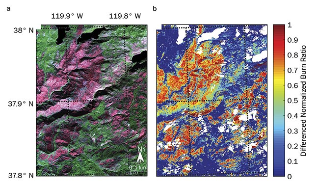
A post-fire color composite image captured by JPL’s AVIRIS over the 2013 Rim fire in California (a). The same area shown as a hyperspectral differenced normalized burn ratio (b). See Reference 1. Courtesy of Sander Veraverbeke.
SBG is still in the design phase, but it is proposed to consist of a visible to SWIR (VSWIR) spectrometer with high spatial and spectral resolution and high signal to noise. A thermal infrared radiometer will likely have two MWIR bands and five to six thermal IR bands. SBG’s spaceborne VSWIR instrument represents an evolution from the airborne AVIRIS-NG. It was primed for space in a NASA mission for the Earth Surface Mineral Dust Source Investigation (EMIT), which is scheduled to launch in 2022, JPL’s Cawse-Nicholson said.
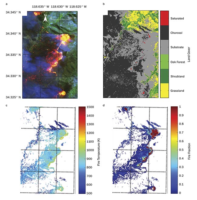
A color composite of data captured by JPL’s AVIRIS over parts of the active 2003 Simi fire in California (a), along with information about land cover (b), fire temperature (c), and fire fraction (d). See Reference 1. Courtesy of Sander Veraverbeke.
SBG promises to remedy the most underutilized technology for wildfire monitoring: measurements made in the MWIR. “This part of the spectrum can be used to measure the temperatures of very hot fires that often saturate bands in the thermal infrared,” Cawse-Nicholson said. “Coarser-resolution midwave measurements are made by polar orbiters and geostationary satellites. But SBG will provide a unique 60-m measurement with two- to three-day repeat, which will provide opportunities for wildfire detection and monitoring.”
Reference
1. S. Veraverbeke et al. (2018). Hyperspectral remote sensing of fire: state-of-the-art and future perspectives. Remote Sens Environ, Vol. 216, pp. 105-121.