SOFTWARE
Teledyne Optech Inc.Request Info
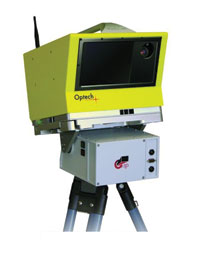 Optech Inc. has introduced georeferencing software for its ILRIS-3D scanner that improves survey-oriented work flow and allows users to cut data-collection and postprocessing times. Its functionalities, which include re-section and backsight, allow point clouds to be located at each setup and enable a fully automated process for finding field survey targets. The software also provides direct real-time confirmation of each scanned target and allows the operator to accept or reject it based on the resulting data quality.
http://www.teledyneoptech.com
/Buyers_Guide/Teledyne_Optech_Inc/c10793
Published: November 2008
REQUEST INFO ABOUT THIS PRODUCT
* First Name:
* Last Name:
* Email Address:
* Company:
* Country:
Message:
When you click "Send Request", we will record and send your personal contact information to Teledyne Optech Inc. by email so they may respond directly. You also agree that Photonics Media may contact you with information related to this inquiry, and that you have read and accept our
Privacy Policy and
Terms and Conditions of Use.
Register or login to auto-populate this form:
Login
Register
* Required