
MountainsMap 6.2 Software
Digital SurfRequest Info
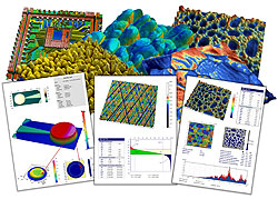
BESANÇON, France, Nov. 23, 2011 — Digital Surf Sarl's MountainsMap 6.2 surface imaging and metrology software integrates Chinese GB/T standard references for surface texture parameter families, extending the “right parameters wherever you are” feature to include eight national references and ISO references.
It also supports the new ISO 25178-72 (OpenGPS) X3P data format and six others for optical and scanning probe microscopes. New features speed up the creation of surface metrology reports and provide enhanced surface imaging and analysis. A new application allows users to install optional modules for advanced surface analysis and to try them free of charge for up to 30 days. A variety of modules are available, including ones for advanced surface texture analysis in accordance with the latest ISO 25178 and ISO 16610 standards.
 Optional modules such as advanced surface texture analysis, grains and particles analysis, 3-D Fourier analysis and statistics are available on a free trial. Automation tools facilitate the separation of two steps: preprocessing surface measurements and carrying out metrological analysis. Real-time previews of the results of applying preprocessing and metrological operators save time during report creation.
The new features enhance various surface imaging and analysis applications and provide greater data security. Higher quality images and smooth edges are obtained during resampling using new spline interpolation methods. Subsurfaces that require independent analysis can be extracted from geometric and layered surfaces with or without automatic leveling. Dimensional analysis of micro and nano contours is accelerated by a tool that automatically associates line segments, arcs and circles with features on profiles during the definition of nominal form. The analysis of protein unfolding adhesion events in accordance with the wormlike chain model in atomic force microscopy applications benefits from greater sensitivity. The auto-save tool maximizes data security, with the current document auto-saved every 15 min; auto-saved files can be retrieved for up to 48 h.
Users of MountainsMap 6.0 and 6.1 can download a free MountainsMap 6.2 update, while users of earlier versions benefit from a straightforward upgrade path.
https://www.digitalsurf.com
/Buyers_Guide/Digital_Surf/c3696
Published: November 2011
REQUEST INFO ABOUT THIS PRODUCT
* First Name:
* Last Name:
* Email Address:
* Company:
* Country:
Message:
When you click "Send Request", we will record and send your personal contact information to Digital Surf by email so they may respond directly. You also agree that Photonics Media may contact you with information related to this inquiry, and that you have read and accept our
Privacy Policy and
Terms and Conditions of Use.
Register or login to auto-populate this form:
Login
Register
* Required