
Unmanned Ground Vehicle
Leica Geosystems AG (See Hexagon Manufacturing IntelligenceRequest Info
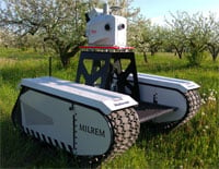 Milrem AS and Leica Geosystems AG have announced the Pegasus Multiscope, an unmanned ground vehicle for off-road use in surveying, security and monitoring applications.
For automated border patrols, the multiscope can follow a preprogrammed route and detect disturbances. Using the cameras calibrated to the 3D point cloud, change detection with Leica MapFactory for AutoCAD can be seen within 2 to 3 cm. If more detailed base maps are required, thermal imaging is also available.
For civil engineering use, the system is able to more easily and cost-effectively traverse potentially dangerous or difficult areas such as unstable riverbanks when surveying for dam construction. Ground level autonomous monitoring of large-scale farming offers the potential of real-time essential data for improved productivity. The multiscope can provide the data for critical agricultural decisions such as smart monitoring for field drainage or ripeness.
http://www.leica-geosystems.com/metrology
/Buyers_Guide/Leica_Geosystems_AG_See_Hexagon_Manufacturing/c8354
Published: June 2016
REQUEST INFO ABOUT THIS PRODUCT
* First Name:
* Last Name:
* Email Address:
* Company:
* Country:
Message:
When you click "Send Request", we will record and send your personal contact information to Leica Geosystems AG (See Hexagon Manufacturing Intelligence by email so they may respond directly. You also agree that Photonics Media may contact you with information related to this inquiry, and that you have read and accept our
Privacy Policy and
Terms and Conditions of Use.
Register or login to auto-populate this form:
Login
Register
* Required