
Playing “hide and seek” with warblers – and winning
Suddenly, identifying the locations of migratory birds has gotten quite a bit easier.
Birds are creatures of habit, and they tend to have certain features
in mind when seeking out places to feed or to nest. Migratory birds, such as the
black-throated blue warbler, leave their Caribbean and South American homes every
year for new ones in the forests and groves of North America. Ornithologists trying
to predict where these warbler populations might be found each year have been relegated
to almost literally beating the bushes. Now, using lidar and satellite imaging,
the task has become less arduous.
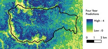
A map generated from four years of lidar data has helped predict the habitat preferences
of black-throated blue warblers in New Hampshire. Courtesy of Scott J. Goetz, Woods
Hole Research Center.
Many bird species choose their habitats by considering how a patch
of forest is structured. The canopy height and branching patterns of the trees,
the abundance of leaves and how they are splayed along their branches all contribute
to how birds shop for a new home.
To gauge how birds evaluate forest areas, scientists were faced
with plotting out the dimensions of these factors – a painstaking effort that
absorbed a lot of time and effort.
Now, researchers led by Scott J. Goetz of Woods Hole Research
Center in Falmouth, Mass., have combined satellite data, a ground-based bird census,
a lidar system and a novel modeling technique to predict the presence of songbirds
in a New Hampshire forest. Their results were published recently in the journal
Ecology.
According to Goetz, NASA’s Laser Vegetation Imaging Sensor
(LVIS) was the key to his group’s successful technique. The portable lidar
system sends laser pulses from an airplane toward the forest canopy, recording the
points at which signals bounced back from the leaves and branches of trees and shrubs,
as well as from land surfaces and other objects. Beam divergence resulted in spot
sizes of 10 m or more.
When combined with satellite data, the LVIS data provided such
details as whether the vegetation had mostly high branches or many canopy layers
beneath treetops.
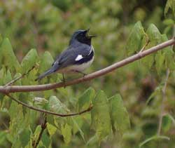
A black-throated blue warbler sings from a perch in its preferred habitat of low-lying shrubs at the Hubbard Brook Experimental Forest in West Thornton, N.H. Courtesy of Matthew G. Betts, Oregon
State University in Corvallis.
In one study, Goetz and his colleagues studied the black-throated
blue warbler. They ranked various areas in Hubbard Brook Experimental Forest in
West Thornton, N.H., as being good, fair or poor for warbler interest based on the
canopy structure. The areas that they ranked as good for the warbler matched actual
ground data – that is, the warblers were spotted within the actual habitat
– about 90 percent of the time.
With further refinement of the system’s accuracy, the group
expects to be able to track the lifestyles of flying squirrels and other mammals,
and perhaps even salamanders and other creatures that slink along the ground.
Published: September 2010