A new generation of portable, drone-based thermal imagers helps identify subjects in complex or low-contrast scenes.
KELSEY JUDD, FLIR SYSTEMS
The enormous growth in the drone, or small unmanned aerial vehicle (UAV), industry over the past five years has changed the way many industries operate, and the trend is not slowing down. Business Insider Intelligence predicts year-over-year growth of 31.3 percent in the commercial drone market and 51 percent in the enterprise drone market between 2018 and 20211. This explosion in access to affordable aerial imaging is changing the way work is done in a variety of fields, especially jobs that involve detecting people on the ground, such as search and rescue and law enforcement, and thermography jobs that require accurate noncontact temperature measurement from a bird’s-eye view.
Human detection
A drone equipped with a thermal camera can greatly improve the probability of detecting a missing person as quickly as possible. Small drone systems are portable and can be deployed rapidly, making them a valuable tool for search and rescue teams. It is typical for one operator to pilot the drone while another person closely views the video downlink for signs of life in the scene below. A camera showing the visible spectrum is certainly helpful, but it can be challenging to identify a subject in complex or low-contrast scenes, especially if there are obscurations from trees, brush, low light, and shadows (Figure 1a). When using a thermal camera, the contrast between a subject’s body temperature and his or her surroundings makes detection much easier, even through foliage (Figure 1b).
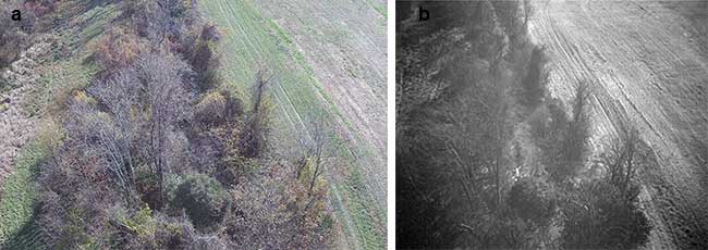
Figure 1. Due to temperature differences between the subject and the environment, thermal imagers provide a significant advantage in search and rescue. The subject cannot be seen with a visible spectrum camera (a) but is seen with thermographic imaging (b). Courtesy of FLIR Systems Inc.
Dual visible and thermal sensors with picture-in-picture operating mode provide the best of both worlds, offering high-contrast thermal imagery for improved detection while allowing the pilot team to direct other search party members to the subject using landmarks and reference points more clearly identified through the visible spectrum imagery.
Drone-based thermal imagers also prove to be a critical tool for law enforcement operations involving finding and tracking persons of interest. Airborne thermal cameras are not new in this field. In a well-publicized case, a helicopter-mounted thermal camera was critical in finding one of the Boston Marathon bombers hiding inside a covered boat2. Drone-based systems offer some advantages over helicopters, including ease of deployment, the ability to fly in tighter quarters, availability of trained operators, and lower operating costs. The large gimballed payloads used on police helicopters are equipped with higher-performance camera systems, but features such as isotherms on drone-based cameras are helping to close that technological gap.
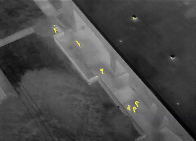
Figure 2. Isotherm palettes help highlight objects within a specific temperature range. Here, a police search party and a dog seek a subject hiding in the upper left of the image. Courtesy of FLIR Systems Inc.
Isotherm refers to an infrared colorization that highlights objects within a certain temperature range. In Figure 2,
an isotherm has been enabled for a temperature range of approximately 85 to 100 °F to highlight humans in the scene. Although the rest of the scene remains displayed in a thermal gray scale, pixels within that temperature range are highlighted with a different color palette. This further enhances the contrast and enables operators to instantly find any object in the range of a standard person’s body temperature. A drone flying an isotherm-enabled thermal camera can quickly scan an area and assist in finding persons of interest.
Thermography
Isotherm imaging uses temperature information to improve detection of objects of interest, but other applications rely on image-based radiometric temperature measurement, known as thermography. A drone allows an operator to move and position a thermal camera to quickly make temperature measurements over large areas and in difficult or dangerous environments. For example, a small unmanned aerial system (sUAS) can measure the surface temperature of a heat exchanger on a roof, a faulty connection on a high-voltage transmission line, solar cells in a solar panel, and crop distributions across large agricultural fields.
A key feature of a thermographic image is the ability to measure the temperature of every pixel in the picture.
Information about the atmospheric temperature, humidity, distance to the subject, background temperature, and subject emissivity (essentially the opposite of reflectivity; a perfectly emissive object reflects no light) all play a role in differences between an object’s true temperature and the apparent temperature measured by an infrared camera. Thermographic users can edit these parameters in postprocessing based on known calibrated data taken in the field to improve measurement accuracy.
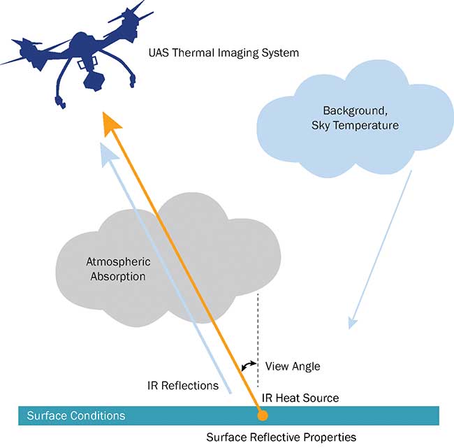
Figure 3. Remote drone thermal imaging systems need to address unique radiometric temperature challenges related to the environment and the subject material properties. UAS: unmanned aerial system. Courtesy of FLIR Systems Inc.
It is important to note that radiometric temperature measurements are surface infrared measurements. Radiometric measurements should be restricted to optically opaque materials. Metals and organic material are usually completely opaque, making radiometric measurements straightforward given the right camera system. Certain materials, such as sapphire glass, zinc sulfide glass, and zirconia oxides, are semitransparent in the infrared spectrum, which makes radiometric measurements and analysis significantly more complex. Accurate radiometric measurement of these surfaces must account for the total volumetric and through-plane temperature of the material. Remote temperature sensing of a surface relies on the ability to accurately compensate for surface characteristics, atmospheric interference, and the position of the imaging system (Figure 3).
Whale spotting
Wildlife conservation and agriculture are two areas where drone-based thermal systems are enabling more advanced thermography. Iain Kerr, CEO of Ocean Alliance — an organization dedicated to whale and ocean conservation through research — and his team are using thermal imaging to make the first-known whale body temperature measurements by capturing radiometric images of surfacing whales (Figure 4). Ocean Alliance uses several drones to collect biological samples exhaled from a surfacing whale’s blowhole.
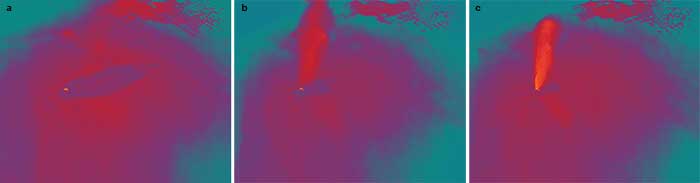
Figure 4. Thermographic imagery of a whale surfacing. Thermography is used to measure the body temperature of different whale species. Bright orange shows the whale’s blowhole (a) and blow (b and c). Courtesy of FLIR Systems Inc.
One previous challenge Kerr faced was capturing the right imagery at the right time. There is very little time during a blow in which the blowhole is exposed, and early drone thermal camera systems could only capture thermographic images at a rate of 1 fps. This is due to the higher data bandwidth required for thermography. To adequately capture the full dynamic range of the thermal sensor, a 16-bit uncompressed image is required. Earlier images were captured as 8-bit video to ensure that imagery of the blow event was at least captured, but newer systems, such as the FLIR Duo Pro R, can record 16-bit radiometric video at
30 fps because of greater onboard processing power. This means that on future expeditions, Kerr and his team can simply set their camera to record radiometric video and fly their mission, capturing temperature values of every pixel for the entire flight duration.
Dual visible and thermal sensors with picture-in-picture operating mode provide the best of both worlds, offering the high-contrast thermal imagery for improved detection while allowing the pilot team to direct other search party members to the subject using landmarks and reference points more clearly identified through visible imagery.
For less dynamic thermographic subjects, the ability to program a waypoint route and perform identical drone flight patterns at different times throughout the day or year opens doors for agricultural experts. Whereas hiring a helicopter can be impractical for a routine inspection to monitor crop health and soil moisture levels, a small drone can easily be flown over the same route almost with a single button push. Weekly flights can help monitor the health of a seasonal crop, and multiple flights in a single day can show issues related to “hot spots” in a field. Preplanned flights are also useful for search and rescue to ensure complete coverage of a search area, and for rooftop or solar panel inspections over large, repetitive areas.
As drone adoption increases across a variety of industrial and research applications to get more and better data, the use of airborne thermal sensors is greatly aiding drone operators in a variety of fields. From accurately measuring whale blowhole temperatures to finding warm bodies in a cold, dark, forested area, drone-based thermal imaging platforms will continue to improve the way these and other jobs are performed.
Meet the author
Kelsey Judd has been working on infrared technologies at FLIR Systems as a systems engineer and project manager since 2012. He holds a bachelor’s degree in electrical engineering and a master’s in technology management from the University of California, Santa Barbara.
References
1. http://www.businessinsider.com/drone-industry-analysis-market-trends-growth-forecasts-2017-7
2. https://www.photonics.com/a53651/Thermal_Imaging_Helps_Nab_Bombing_Suspect